Update on Tropical Depression in the East Sea
A tropical depression is currently active in the eastern waters of the North East Sea, with winds reaching
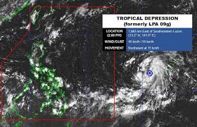
A tropical depression has officially formed in the Pacific Ocean, located near the East Sea, as reported by the Philippine Atmospheric, Geophysical and Astronomical Services Administration (PAGASA). As of September 22, 2026, at 2 PM, the center of the tropical depression was positioned at approximately 13.2 degrees North latitude and 141.6 degrees East longitude, about 1,885 kilometers southeast of Luzon Island.
The tropical depression is moving northward at a speed of approximately 15 kilometers per hour, with maximum sustained winds near its center reaching 45 kilometers per hour and gusts up to 55 kilometers per hour. Currently, the depression is outside the Philippine Area of Responsibility (PAR) and has not yet significantly impacted nearby land areas.
According to the National Center for Hydro-Meteorological Forecasting, as of the afternoon of September 22, the northern Gulf of Tonkin, the waters from South Quang Tri to Ca Mau, and the Gulf of Thailand are experiencing scattered rain and thunderstorms. A tropical convergence line is situated between 10-13 degrees North, connecting with the newly formed depression.
Forecasts for the night of September 22 and the day of September 23 indicate that the northern Gulf of Tonkin, the waters from South Quang Tri to Ca Mau, and the southern part of the East Sea (including the Spratly Islands) will experience rain and thunderstorms. There is a high possibility of tornadoes occurring during thunderstorms, with winds reaching levels 7-8 and waves exceeding 2.0 meters.
All vessels operating in these areas are at risk of being affected by tornadoes and strong winds. Residents and tourists planning to visit these coastal regions are advised to monitor weather developments closely and follow local guidance to ensure safety during their travels.