Tropical Depression in the East Sea Unlikely to Intensify into a Storm
The National Center for Hydro-Meteorological Forecasting has reported that a tropical depression located in
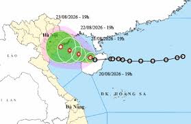
A tropical depression in the East Sea is moving northwest and is expected to strengthen into a storm within the next 24 hours as it approaches the northern Gulf of Tonkin.
According to the National Center for Hydro-Meteorological Forecasting, as of 7 PM on August 20, the center of the tropical depression was located at approximately 19.7 degrees North latitude and 109.5 degrees East longitude, near the northwestern area of Hainan Island, China. The maximum wind speed near the center of the tropical depression is currently at level 6, with gusts reaching level 8.
The tropical depression is moving primarily in a northwest direction at a speed of about 5 km/h. It is forecasted that within the next 24 hours, it will continue to move northwest at the same speed and enter the Gulf of Tonkin. By 7 PM on August 21, the center of the tropical depression is expected to be at around 20.0 degrees North latitude and 108.4 degrees East longitude, approximately 200 km southeast of Hai Phong.
At this time, the tropical depression is likely to strengthen into a storm, with wind speeds reaching level 8 and gusts up to level 10. The Gulf of Tonkin has been warned to be at risk level 3 for natural disasters.
In the following 24 hours, the storm is expected to continue moving northwest at a speed of 3-5 km/h. By 7 PM on August 22, the storm's center is predicted to be at around 20.3 degrees North latitude and 107.6 degrees East longitude, approximately 110 km southeast of Hai Phong.
The storm's intensity at this point is forecasted to be at level 8, with gusts reaching level 10. The risk level for natural disasters remains at level 3 for the Gulf of Tonkin.
From 48 to 72 hours later, the storm is expected to continue moving northwest at a speed of 3-5 km/h and gradually weaken. On the sea, the Gulf of Tonkin will experience increasing winds of levels 6-7, with winds near the storm center reaching level 8 and gusts at level 10. Waves could rise to 2.5-3.5 meters, creating rough sea conditions.
Maritime activities in the dangerous areas are warned to be affected by thunderstorms, strong winds, and large waves. Vessels are advised to closely monitor the developments of the tropical depression and the storm and to take appropriate precautions.
Tourists planning to visit these coastal areas should pay attention to the weather updates, follow local guidance, and avoid going out to sea during rough conditions to ensure safety.