Tropical Depression May Form in Gulf of Tonkin, Heavy Rains Expected
A tropical depression is expected to form in the Gulf of Tonkin, with northern provinces bracing for heavy
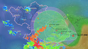
A tropical depression is predicted to move into the Gulf of Tonkin early tomorrow morning, August 21, with the potential to strengthen into a level 8 storm, bringing winds of up to level 10. According to Mai Van Khiem, Director of the National Center for Hydro-Meteorological Forecasting, the depression was located north of Hainan Island, China, at 1 PM on August 20, with maximum winds of 49 km/h (level 6), and is moving westward at a speed of 5-10 km/h.
The meteorological agency forecasts that by early tomorrow, the tropical depression will enter the Gulf of Tonkin and may intensify into a level 8 storm. Khiem noted that the depression is currently situated on the tropical convergence zone, which runs through the central northern plains and northern central regions of Vietnam. The system is expected to move slowly, and the large-scale flow patterns and interactions with surrounding weather systems are still changing. Therefore, forecast models show some dispersion regarding the trajectory, intensity, and areas that will be directly affected.
The National Center for Hydro-Meteorological Forecasting has presented two scenarios for the tropical depression. The first scenario, with a probability of 60-70%, suggests that after entering the Gulf of Tonkin, the depression will move slowly and strengthen into a level 8 storm, subsequently moving northward and making landfall along the northeastern coast. Heavy rainfall in northern Vietnam is expected to increase from August 21, particularly affecting regions such as Cao Bang, Thai Nguyen, Bac Ninh, Hung Yen, Hai Phong, and Quang Ninh.
The second scenario, with a probability of 30-40%, is considered extreme in terms of rainfall. In this case, after entering the Gulf of Tonkin and strengthening into a storm, the tropical depression may continue to move slowly westward, making landfall in the southern northern plains and then weakening. This scenario could lead to heavy to very heavy rainfall in eastern northern Vietnam, peaking from August 22 to 25.
Khiem emphasized that these scenarios may change as the tropical depression moves deeper into the Gulf of Tonkin in the next 1-2 days. Local authorities and residents are advised to closely monitor the situation and remain vigilant for strong winds, thunderstorms at sea, and heavy rainfall in northern Vietnam.
Since the beginning of the year, the South China Sea has recorded two storms. The first, Storm Maysak, formed in early July, reached level 9 with gusts of level 11, making landfall in Mong Cai, Quang Ninh, on the night of July 4, with wind speeds of level 8-9 and gusts of level 12. On July 23, a tropical depression near the South China Sea intensified into Storm Noul, which then headed towards Guangdong, China, without directly affecting mainland Vietnam.