Tropical Depression in the East Sea Unlikely to Intensify into a Storm
The National Center for Hydro-Meteorological Forecasting has reported that a tropical depression located in
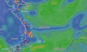
The National Center for Hydro-Meteorological Forecasting has announced that a low-pressure area located in the South China Sea is likely to strengthen into a tropical depression in the coming days. This development is expected to cause unfavorable weather conditions, particularly in maritime regions.
As of September 10, strong winds of up to level 5, with gusts reaching level 6, have been reported in the Phu Quy area, while the Spratly Islands have experienced winds gusting up to level 7. The central and southern parts of the South China Sea, including the waters from Ca Mau to An Giang and the Gulf of Thailand, are experiencing scattered rain showers and thunderstorms.
The tropical convergence zone, located at approximately 14-17 degrees north latitude, is linked to the low-pressure area situated at coordinates 14.5-15.5 degrees north latitude and 114.5-115.5 degrees east longitude. Forecasts indicate that the low-pressure system will intensify into a tropical depression within 1-2 days.
On the night of September 10, areas from Lam Dong to Ho Chi Minh City are expected to experience strong winds of level 5, with gusts reaching levels 7-8, leading to rough seas with wave heights of 2-3 meters. Additionally, the Gulf of Tonkin and the northern part of the North Sea will see winds of level 6, with gusts of level 7-8, and similar wave heights.
Rain showers and thunderstorms are anticipated in the Gulf of Tonkin, the waters from Nam Quang Tri to Ca Mau, and the southern part of the North Sea, including the Paracel Islands and the central and southern South China Sea. There is a high likelihood of tornadoes and strong gusts of wind reaching levels 7-8, with waves exceeding 2 meters.
On September 11, the northeastern winds in the Gulf of Tonkin and the northern part of the North Sea will reach level 6, with gusts of level 7-8, and waves of 2-4 meters. The waters from Lam Dong to Ho Chi Minh City will also experience similar conditions.
The meteorological agency has issued a warning of a level 2 natural disaster risk for maritime areas. All vessels operating in these regions are at high risk from strong winds and large waves. The weather at sea is expected to remain complex, and updates on strong winds and high waves will be provided regularly in the coming days.