Tropical Depression Expected to Strengthen into Typhoon No. 5
A tropical depression in the East Sea is forecasted to strengthen into Typhoon No. 5 within the next 24
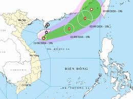
Tropical Depression Set to Strengthen into Storm No. 5
As of September 1, 2026, the National Center for Hydro-Meteorological Forecasting has reported that a tropical depression in the East Sea is expected to intensify into Storm No. 5. By 7 PM today, the center of the tropical depression is located at approximately 20.1 degrees North latitude and 114.4 degrees East longitude, over the northern waters of the North East Sea.
The tropical depression is moving in an east-northeast direction at a speed of 20-25 km/h and is likely to strengthen into a storm. The maximum wind speed near the center of the storm is forecasted to reach level 8, with gusts up to level 10. The risk level for natural disasters is classified as level 3 for the northern waters of the North East Sea.
Due to the influence of the tropical depression, the northern waters of the North East Sea will experience strong winds of levels 6-7, gusting to levels 8-9, with wave heights ranging from 2.0 to 4.0 meters. Areas near the storm's center may see winds reaching level 8 and gusts of level 10, with waves reaching heights of 3.0 to 5.0 meters, creating very rough seas.
Maritime activities in these hazardous areas may be affected by thunderstorms, strong winds, and high waves. Residents and tourists planning to visit these coastal regions are advised to closely monitor weather developments and follow local guidance, avoiding venturing out to sea during rough conditions to ensure safety.
Inland weather forecasts for today include:
Residents are encouraged to stay informed about the weather and take necessary precautions as Storm No. 5 approaches.



