Japan Issues Tsunami Warning After 7.1 Magnitude Earthquake
A powerful 7.1 magnitude earthquake struck Kumamoto Prefecture on Japan's Kyushu Island, prompting
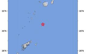
On September 12, 2026, an earthquake measuring 5.1 on the Richter scale struck near the Ryukyu Islands of Japan, according to the United States Geological Survey (USGS). The quake occurred at 20:32 GMT, approximately 101 kilometers south of Yudomari, at a depth of 45.5 kilometers. Meanwhile, the German Research Centre for Geosciences (GFZ) recorded the earthquake with a slightly higher magnitude of 5.3, noting a depth of 10 kilometers.
The Malaysian Meteorological Department (MetMalaysia) reported that the earthquake was recorded around 4:33 AM local time on September 13, with its epicenter located 231 kilometers south of Kagoshima, Japan, at a depth of around 40 kilometers. Initial assessments indicated that the earthquake did not pose a tsunami threat to Malaysia.
The Ryukyu Islands, located in southwestern Japan, are situated in a seismically active zone due to their proximity to tectonic plate boundaries. The differing intensity and depth estimates from USGS and GFZ are not unusual in early earthquake assessments, as data can be adjusted as more information becomes available from various monitoring stations.
As of now, there have been no reports of damage or injuries resulting from the earthquake. Authorities continue to monitor the situation closely, ensuring public safety in the region.