Typhoon Surigae Strengthens with High Winds and Heavy Rain
Typhoon Surigae, also known as Queenie, is intensifying with wind gusts reaching 105 km/h as it moves
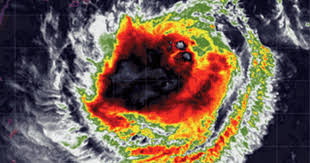
Typhoon Surigae, locally named Queenie, remains strong over the waters of the Philippines, with maximum sustained winds of 95 km/h near its center and gusts up to 115 km/h. As of September 26, at 4 AM, the storm was approximately 600 km east of Itbayat, Batanes, moving west-northwest at a speed of 15 km/h.
By 8 AM, Surigae's center was located about 575 km east-northeast of Itbayat, with wind speeds increasing to 110 km/h and gusts reaching 135 km/h. The storm is slowing down, now moving at about 10 km/h in a west-northwest direction.
The Philippine Atmospheric, Geophysical and Astronomical Services Administration (PAGASA) predicts that Typhoon Surigae will continue to decelerate over the next 12 hours while moving west-northwest before shifting to a north-northeast direction by the morning of September 27. The typhoon is expected to strengthen further by the evening of September 26 or on September 27, and will likely intensify as it moves over the waters south of Okinawa.
It is anticipated that Surigae will begin to weaken starting September 28. The storm is projected to exit the Philippine Area of Responsibility (PAR) sometime between the afternoon and evening of September 27.
In the next 24 hours, a tropical convergence zone is expected to bring cloudy skies, scattered rain, and thunderstorms across many islands in the Philippines. PAGASA has issued wind warnings across the country, indicating light to moderate winds, while the sea conditions are expected to be mild to moderate.
Moreover, after Surigae leaves PAR, two more systems resembling tropical cyclones may form in the first week of October.