Super Typhoon Ba Vi Affects East Sea with Strong Winds
Super Typhoon Ba Vi is currently impacting the East Sea, causing strong winds and high waves. The storm is
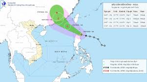
Typhoon Noul is projected to enter the East Sea tonight and early tomorrow morning (July 25), becoming Typhoon No. 2. The storm is expected to affect the weather conditions in the northeastern waters of the North East Sea.
According to the National Center for Hydro-Meteorological Forecasting, as of 1 PM on July 24, the center of Typhoon Noul was located at approximately 18.7 degrees North latitude and 122.6 degrees East longitude, about 90 km east-northeast of Luzon Island in the Philippines. The maximum wind speed near the center of the storm was recorded at levels 8-9 (62-88 km/h), with gusts reaching level 12. The storm is moving in a west-northwest direction at a speed of about 25 km/h.
In the next 24 hours, the typhoon is expected to continue moving west-northwest at a speed of approximately 25 km/h and may strengthen further. By 1 PM on July 25, the storm's center will be located at around 21.3 degrees North latitude and 117.9 degrees East longitude, in the northeastern waters of the North East Sea, about 430 km southeast of Hong Kong.
The wind intensity is forecasted to reach levels 10-11, with gusts up to level 13. The dangerous area is expected to be north of latitude 18 degrees North and east of longitude 115 degrees East. The risk level for natural disasters in the northeastern waters of the North East Sea is classified as level 3.
Over the next 48 hours, the typhoon will continue moving west-northwest at a speed of 15-20 km/h and will gradually weaken. By 1 PM on July 26, the storm's center will be located at approximately 23.7 degrees North latitude and 114.8 degrees East longitude, over land in the southeastern part of Guangdong Province, China.
The wind intensity is expected to decrease to levels 8-9, with gusts reaching level 11. The dangerous area will be north of latitude 19.5 degrees North and east of longitude 113.5 degrees East, with a risk level of 3 for the northeastern waters of the North East Sea.
In the following 60 hours, the typhoon will shift to a north-northwest direction at a speed of 15-20 km/h and will weaken into a tropical depression, eventually dissipating into a low-pressure area with winds below level 6. By 1 AM on July 27, the center of the low-pressure area is expected to be located at approximately 25.5 degrees North latitude and 114.3 degrees East longitude, over land in southeastern Guangdong Province, China.
Regarding the impact of the typhoon, current forecasts indicate that Typhoon Noul is likely to make landfall in Guangdong Province, China (with an 80% probability) and is less likely to directly affect mainland Vietnam.
On the sea, from the evening of July 24, the northeastern waters of the North East Sea will experience increasing winds of levels 6-7, rising to levels 8-9, with wave heights of 3-5 meters. Near the storm's center, winds will reach levels 10-11, with gusts up to level 13 and wave heights of 4-6 meters. The sea will be extremely rough, and vessels operating in these dangerous areas may face severe thunderstorms, strong winds, and large waves.