Typhoon Mekhala Strengthens, Could Become a Super Typhoon
Typhoon Mekhala has been intensifying and is forecasted to reach super typhoon status within the next 12 to
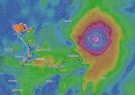
Super Typhoon Ba Vi is significantly affecting the East Sea, with winds reaching levels of 6-7 and waves soaring between 3-5 meters. According to the National Center for Hydro-Meteorological Forecasting, as of 7 AM today, the typhoon was located approximately 810 km from Luzon Island in the Philippines, 1,100 km from Taiwan, and 1,400 km from Fujian Province in China. The maximum wind speed recorded is 16 (up to 201 km/h), with gusts exceeding 17.
The storm is currently moving west-northwest at about 20 km/h. Over the next 24 hours, it is expected to continue on this path while maintaining its super typhoon status before gradually weakening. By July 10, the center of the storm is forecasted to pass north of Taiwan with an intensity of around 15 (maximum 183 km/h) and gusts above 17.
By the evening of July 11, the typhoon is likely to make landfall on the eastern coast of Fujian Province, with wind speeds of 13-14, before further weakening as it moves inland. The Japan Meteorological Agency reports that the super typhoon is currently sustaining winds of around 180 km/h as it approaches Taiwan, while Hong Kong meteorologists estimate wind speeds of 205 km/h upon reaching Fujian.
The meteorological agency has indicated that Ba Vi is not expected to enter the East Sea. However, due to the extensive circulation of the super typhoon, southwestern winds in the southern East Sea, including the Spratly Islands, will intensify to level 6. From July 9 to 11, winds across the northern, central, and southern East Sea, including the Paracel and Spratly Islands, could reach levels of 6-7, with very strong sea conditions.
The National Center for Hydro-Meteorological Forecasting advises vessels operating in these areas to closely monitor weather developments, seek safe shelter, or adjust their operational plans accordingly. Ba Vi is the third super typhoon to form in the Northwest Pacific in 2026. Previously, Typhoon Maysak made landfall in Guangxi, China, after passing through the Gulf of Tonkin on July 4, weakening as it moved inland.
According to forecasts, the peak of the typhoon season in 2026 will occur from July to September, with the number of typhoons and tropical depressions in the East Sea expected to be around the average of previous years.