Typhoon Maysak Approaches Northern Vietnam: Heavy Rain Forecast
Typhoon Maysak is expected to make landfall in the Quang Ninh and Hai Phong regions of northern Vietnam this
Typhoon No. 1, officially named Typhoon Maysak, is currently impacting Northeast Vietnam with significant rainfall and strong winds. From the afternoon of July 4 to the end of July 5, the region is forecasted to experience heavy rain, with some areas receiving more than 450mm. This torrential rain increases the risk of flooding, landslides, and other related hazards.
As of the morning of July 4, the National Center for Hydro-Meteorological Forecasting reported that Bach Long Vi has recorded winds reaching level 9, with gusts up to level 10. The nearby Co To Island has experienced winds of level 7, with gusts of level 9, and wave heights reaching 2.25 meters. Other areas, such as Cua Ong, have reported winds of level 6 and gusts of level 8.
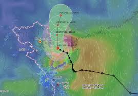
At 10 AM, the center of the typhoon was located over the waters near Bach Long Vi, approximately 145 kilometers southeast of Mong Cai in Quang Ninh Province. The strongest winds near the center of the typhoon are estimated to be between level 8 and 9, equivalent to speeds of 62-88 km/h, with gusts up to level 11. The storm is moving northwest at about 15 km/h.
By 10 PM on July 4, the typhoon is expected to move towards the southern region of Guangxi Province in China, maintaining its intensity at level 8 with gusts of level 10 before gradually weakening into a tropical depression.
The impact of Typhoon No. 1 has led to warnings of dangerous weather conditions in the Gulf of Tonkin, including the special economic zone of Bach Long Vi, Van Don, Co To, Cat Hai, and Hon Dau, where winds are expected to reach levels 6-7. Areas close to the typhoon's center may experience winds of levels 8-9 and gusts of level 11. Wave heights are projected to be between 2-4.5 meters, causing very rough seas.
Meteorological agencies have warned that these conditions could lead to capsizing, sinking, or damage to fishing boats, transport vessels, and tourism boats, as well as risks to aquaculture cages and coastal structures. Particularly in coastal areas of Quang Ninh, Hai Phong, and Hung Yen, winds are expected to increase to level 6 by this afternoon.
The combination of strong winds and high waves could result in localized flooding in river mouths, tidal flats, and low-lying areas, affecting dikes, sea embankments, and coastal infrastructure. Strong winds may also damage roofs, temporary structures, uproot trees, and disrupt electrical and communication systems.
In terms of rainfall, the meteorological agency predicts that from the afternoon of July 4 to the end of July 5, the northeastern region will see rainfall ranging from 70-150mm, while the northeastern mountainous areas could receive between 150-250mm, with localized areas exceeding 450mm. This heavy rainfall poses a risk of flooding in urban areas, industrial zones, and low-lying regions.
Authorities are advising local residents in affected areas to closely monitor the storm's progress, stay updated with forecasts and warnings, and proactively implement disaster prevention measures as guided.