Tropical Storm Higos Strengthens Near the East Sea
Tropical Storm Higos has intensified significantly as it moves over the waters east of the Philippines, with
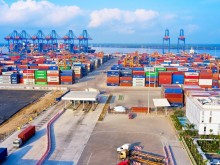
The National Center for Hydro-Meteorological Forecasting has reported that Bach Long Vi Island is currently facing strong winds of level 8, with gusts reaching level 9, due to the impact of Storm No. 1. Nearby Co To Island is also experiencing strong winds of level 6, with gusts of level 8 and wave heights reaching 2.25 meters.
As of 7 AM on July 4, the storm's center was located approximately 70 km east of Bach Long Vi and about 170 km southeast of Mong Cai, Quang Ninh. The maximum wind speed near the storm's center is estimated at levels 8-9 (62-88 km/h), with gusts reaching level 11. The storm is moving northwest at a speed of 15-20 km/h.
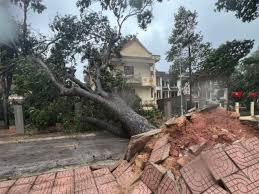
Forecasts indicate that within the next 4-5 hours, the storm's circulation will approach the mainland areas of Quang Ninh and Hai Phong. Starting from noon, coastal areas in these provinces will experience winds of level 5, increasing to level 6, with near-storm areas experiencing winds of levels 7-8 and gusts of levels 9-10. Rainfall is expected to increase significantly from the afternoon into the evening.
By 7 PM on July 4, the storm is projected to continue moving northwest at about 15 km/h, with its center located around 21.6°N - 107.9°E, near the Vietnam-China border. The storm will gradually weaken into a tropical depression, with winds decreasing to level 6 and gusts of level 8 by July 5.
Authorities have issued a warning for the North Gulf of Tonkin, including Bach Long Vi, Van Don, Co To, Cat Hai, and Hon Dau islands, with a disaster risk level of 3. Residents in the affected areas are advised to closely monitor the storm's developments and follow safety guidelines from local authorities.