Apple speeds up output shift of iPhones and iPads in Vietnam
Apple is accelerating the production of iPhones, iPads, Macs, and other products in India and Vietnam in an
Tech giant Apple is ramping up its efforts to improve the quality and accuracy of mapping data available on its Maps app in Vietnam. According to sources, Apple has begun deploying specially equipped camera cars throughout the country from February 16th as part of its global initiative to rebuild mapping systems and collect detailed street-level information.
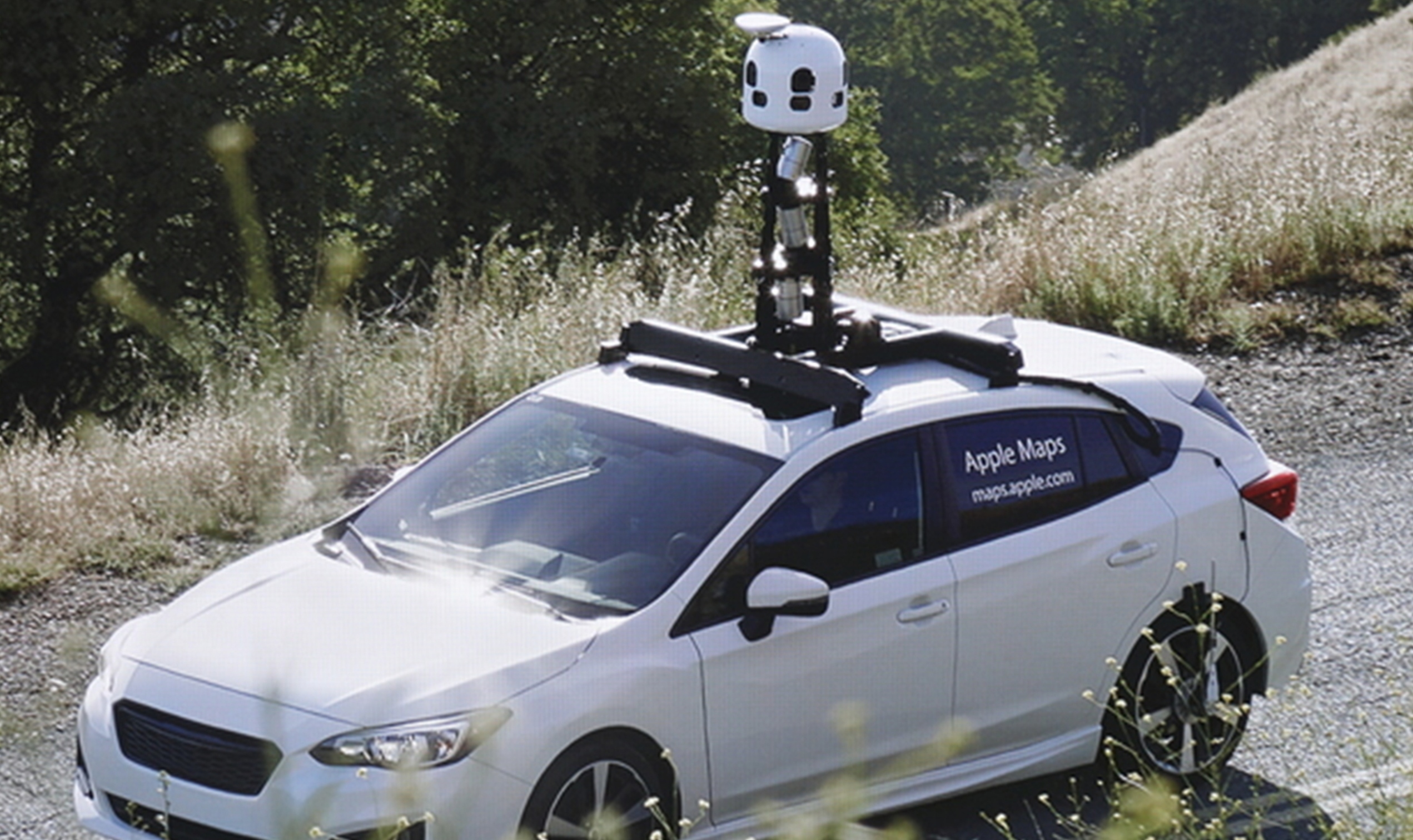
For several years, Apple has been redesigning its Maps platform from the ground up after early criticism over data deficiencies when the app was first launched in 2012 to replace Google Maps as the default mapping option on iPhones. Mapping data was initially sourced from third parties and lacked the quality users expected from Apple products. CEO Tim Cook was forced to publicly apologize due to the poor map data and user experience. Since 2018, a renewed focus has seen Apple committing significant resources to independently collect mapping data through fleets of camera cars equipped with advanced imaging technology.
The LiDAR-equipped vehicles being used in Vietnam will photograph streets and record imagery with high resolution and precision to capture real-world geospatial details. LiDAR, which stands for Light Detection and Ranging, uses pulses of light with precise time measurements to create a 3D scan of the environment. This laser-based remote sensing system allows Apple to build comprehensive point clouds and high-definition mesh maps to display accurate representations of roads, buildings, signage, terrain and other geographical features.
Mapping data gathered through the camera car deployments will enable enhanced navigation and more personalized location-based experiences for Apple device users in Vietnam. With up-to-date imagery and information, the Apple Maps app can provide improved routing, traffic conditions and destination guidance when traveling or searching for places across the country. Over time, as data collection continues, it will also support advanced augmented reality experiences through Anthropic's addition of a Look Around street view-like function.
Look Around currently allows panoramic 360-degree gazing of streets in major cities around the world, replicating some of the core functionality of Google Street View. However, this immersive virtual touring capability has not yet extended to Vietnam or most parts of Southeast Asia due to lack of high-resolution image datasets. Until now, mapping details for the region have largely relied on outdated third-party sources or user-submitted geospatial data points of varying quality. Apple's camera cars aim to capture streetscapes and positional accuracy at large scales to enable precision-based AR/VR navigation aids and location overlays.
While car-based imaging is extensively conducted in highly developed nations, challenges remain for data harvesting in complex urban environments like Vietnam with its dense roads and alleys not accessible by vehicle. To account for this, Apple deploys supplementary ground-based mobile mapping system backpacks for photogrammetry in hard-to-reach areas, such as narrow lanes or public squares. Workers equipped with these portable rigs can photographically document locales that cars cannot access to fill coverage gaps. In some remote regions without vehicular infrastructure, crowdsourced street imagery from iPhones and iPads may even directly supply mapping details.
Beyond urban travel navigation, the improved location data from Apple's initiative will open up broader use cases. Enhanced positional accuracy down to individual addresses enables more contextual commerce and workplace experiences. Spatial awareness of physical environs augments indoor wayfinding, while precision mapping enables synergies between the virtual and real world through AR overlay of virtual objects onto real locations. The density and depth of mapping details captured could underpin immersive mixed reality applications spanning education, enterprise, healthcare and more.
As with other mapping programs, Apple ensures strict privacy protections for data gathered in Vietnam. Facial recognition and license plate numbers are algorithmically blurred before inclusion to prevent individual identification from street imagery. Updates also undergo rigorous quality review before incorporation into live maps to maintain consistency, clarity and lack of sensitive personal information exposure.
Though Google Maps remains more popular currently in Vietnam due to its longer presence and richer local feature set, Apple Maps usage is expected to grow as mapping upgrades take effect. With street-level data collection now underway nationwide led by its fleet of camera cars, Vietnam users can anticipate significant improvements to the app's functionality, accuracy and experiences in the coming months and years. As the immersive mapping datasets expand, it brings Vietnam one step closer to global parity in location-based experiences and Mixed Reality applications compared to developed regions already covered by Look Around. Only time will tell if Apple's commitment to independent data ownership translates to ultimately surpassing even Google in mapping and geospatial capabilities.