Tropical storm Chaba picks up strength as it moves northwest
NDO - Tropical storm Chaba, the first storm to affect Vietnam this year, is gathering strength, with wind
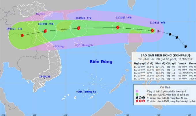
NDO – In the next 24 hours, storm Kompasu is moving west-northwest rapidly at a speed of 20-25 kilometres per hour and further strengthen as it enters East Sea/South China Sea, according to the National Centre for Hydro-Meteorological Forecasting (NCHMF).
At 7am on October 11, the typhoon was centred about 18.6 degrees north latitude and 124.1 degrees east longitude, 250 kilometres east-northeast of Luzon island (the Philippines). The strongest winds near its eye fell to 75-90 kilometres per hour.
As of 7am on October 12, the storm’s centre is projected to be19.1 degrees north latitude and 118.5 degrees east longitude, about 700 kilometres to the east-northeast of Hoang Sa (Paracel) Archipelago. The strongest winds in the area near the centre of storm are expected to be about 75-100 kilometres per hour (level 9-10).
Over the following 24 to 48 hours, it is likely to keep moving west rapidly at a speed of about 25 kilometres per hour, hitting the East Sea and continue to gather more strength. By 7 am on October 13, the storm’s centre will be located at 19.0 degrees north latitude and 112.2 degrees east longitude, about 150 km east of Hainan island (China). The strongest winds near its centre blew at 100-120 kilometres per hour (level 11).
In the 48-72 hours after that, the storm will move west-southwest at a speed of 25 kilometres per hour. As of 7am on October 14, it will be centred 18.5 degrees north latitude and 106.8 degrees east latitude, in the waters from Thanh Hoa to Quang Binh Provinces. The strongest winds in the area near the storm’s eye are expected to be 60-90 kilometres per hour (level 8-9).
Due to the influence of the storm, the north of East Sea is facing strong winds gradually increased to levels 8-9 and then levels 10-11 at night on October 11. The disaster risk at the area is warned at level 3.
In the next 72 to 96 hours, the storm moves quickly in the southwest direction at a speed of about 25 kilometres per hour and will be likely to weaken.
* Due to the remnant of a low-pressure area weakened from the storm No.7 and cold air today, the northern and central northern regions are facing heavy rains and very heavy rains in some places.
During the thunderstorms, there is a possibility of tornadoes, lightning, hail and strong winds. High risks of flash floods and landslides are warned in mountainous.
