Typhoon Mekhala Strengthens, Could Become a Super Typhoon
Typhoon Mekhala has been intensifying and is forecasted to reach super typhoon status within the next 12 to
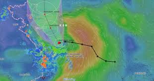
On the morning of July 3, 2026, a tropical depression located in the Northwest region of the Paracel Islands strengthened into Typhoon Maysak, the first typhoon of the year. According to the National Center for Hydro-Meteorological Forecasting, as of 4 AM on July 3, the typhoon was positioned at approximately 17.3 degrees North latitude and 110.1 degrees East longitude, about 120 kilometers south of Hainan Island, China.
The maximum wind speed near the center of the typhoon is estimated at level 8 (62-74 km/h) with gusts reaching level 10. The typhoon is moving westward at a speed of about 10 km/h.
In the next 24 hours, Typhoon Maysak is expected to move in a north-northwest direction at a speed of 10-15 km/h. By 4 AM on July 4, the typhoon's center will be located around 19.5 degrees North latitude and 108.8 degrees East longitude, near the western coast of Hainan Island.
In 48 hours, the typhoon will continue moving north-northwest, reaching the waters off Quang Ninh and Hai Phong by July 5. The winds will remain strong, with maximum speeds near the center of the storm at level 8 and gusts at level 10.
By 72 hours, the typhoon is expected to weaken into a tropical depression and then into a low-pressure area as it approaches southern Guangxi, China.
On the sea, the western part of the North East Sea, including the Paracel Islands, will experience strong winds of level 6-7, and near the center of the typhoon, winds will reach level 8 with waves of 2-4 meters high. Conditions are dangerous and could lead to capsizing or damage to fishing boats and transport vessels.
On land, the coastal areas of Quang Ninh, Hai Phong, and Hung Yen are expected to face strong winds starting July 4, with gusts potentially reaching level 9-10. Heavy rainfall is anticipated in the Northeast and Thanh Hoa, with total rainfall expected to range from 100-200mm, and localized areas could see over 350mm.
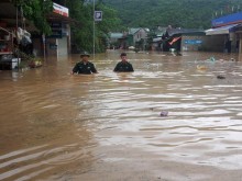
The prolonged heavy rain may lead to flooding in urban areas, industrial zones, and low-lying regions, increasing the risk of flash floods and landslides in mountainous areas.
Authorities recommend that local residents and fishermen closely monitor the typhoon's developments and follow guidance from relevant agencies to mitigate risks. Those living in vulnerable areas, especially near the coast and in low-lying urban regions, should take precautionary measures to secure their homes and properties.