Storm Kompasu to strengthen as it enters East Sea/South China Sea
NDO – In the next 24 hours, storm Kompasu is moving west-northwest rapidly at a speed of 20-25 kilometres
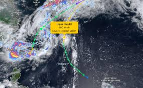
Tropical Storm Higos has rapidly intensified as it approaches the East Sea, according to the latest updates from the Philippine Atmospheric, Geophysical and Astronomical Services Administration (PAGASA). As of 4 AM today, the storm's center was located at approximately 22.8 degrees North latitude and 134.1 degrees East longitude, moving north-northwest at a speed of 25 km/h.
The maximum sustained winds near the center of the storm have reached 95 km/h, with gusts escalating to 115 km/h. The storm's circulation creates a strong wind area with a radius of about 260 km from its center.
Meanwhile, Tropical Storm Mekkhala has weakened to a tropical depression, with maximum winds of 75 km/h. Currently, there are no storm warnings issued in the Philippines as Higos remains far from the coastline.
However, the southwest monsoon is causing strong gusts across much of Luzon today. By June 27, strong winds are expected to impact Batanes, the Babuyan Islands, and the provinces of Ilocos Norte and Ilocos Sur.
In coastal areas, waves may reach heights of up to 3 meters, leading to rough seas. Other regions could see waves between 2 to 2.5 meters. The meteorological agency advises small boats and vessels not equipped to handle rough seas to stay ashore.
On the East Sea, scattered showers and thunderstorms are expected throughout the day and night of June 26, with a risk of tornadoes and strong gusts reaching levels 6-7. Winds are predominantly from the southwest at levels 4-5, with certain areas experiencing gusts of 6-7.
Residents and tourists planning to visit these coastal regions are urged to closely monitor weather forecasts and adhere to local guidance to avoid dangerous conditions during the storm.