Northern Vietnam to Experience First Cold Front with Rain
Northern Vietnam is set to welcome its first cold front of the season, bringing light rain and cooler
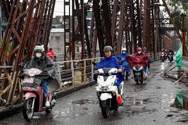
The first cold air of the season is expected to reach Northern Vietnam starting tomorrow, with significant weather changes anticipated. According to Mai Van Khiem, Director of the National Center for Hydro-Meteorological Forecasting, a cold air mass from China is moving towards Vietnam. This cold front is likely to affect Northern provinces between September 9 and 11, with its intensity predicted to be moderate.
As the cold front arrives, rain showers and thunderstorms are expected from the night of September 9 to September 10, with some areas experiencing moderate to heavy rainfall. Following this period, rainfall is expected to decrease rapidly. The maximum daily temperatures in the North are forecasted to drop below 33 degrees Celsius, while nighttime and early morning temperatures may fall below 25 degrees Celsius. In mountainous regions, temperatures could dip below 23 degrees Celsius.
This marks the first cold air event of the fall season for 2026-2027, occurring earlier than the average period of September 12 to October 4. Historically, the earliest cold air event recorded was on August 16, 2003. Thus, the arrival of cold air on September 9-10 is about 3 to 5 days ahead of the average.
In addition to the cold air, a tropical convergence band is forming over the East Sea, with a high probability of developing into a tropical depression between September 12 and 13. There is a 70-80% chance of this occurrence, with a subsequent 30-40% chance of it strengthening into a storm. This scenario, combined with the cold air and tropical convergence, could lead to widespread moderate to heavy rainfall in Central provinces from September 10 to 17, along with risks of thunderstorms, flash floods, landslides, and localized flooding.
According to Mr. Khiem, there are two potential rainfall scenarios: the first scenario (60-70% probability) suggests heavy rain in Central Vietnam from September 10 to 16, particularly affecting areas from Ha Tinh to Gia Lai. The second scenario (30-40% probability) indicates heavy rain starting around September 14 and lasting until about September 17, focusing on the region from Nghe An to Hue.
Furthermore, from September 9 to 12, enhanced southwest monsoon activity is expected to bring increased thunderstorms to the Central Highlands and Southern regions.
The Northeast monsoon is considered a particularly dangerous weather phenomenon. When it arrives, winds in the Gulf of Tonkin can reach levels of 6-7, potentially capsizing boats, while inland winds may reach levels of 4-5, causing damage to buildings, trees, and ongoing construction projects. Strong cold air can also result in heavy rain, strong winds, and extreme weather events such as thunderstorms and hail, especially during transitional months between cold and warm seasons. In the peak winter months (from December to February), clear nights can lead to frost, ice, and even snowfall in high mountainous areas. Prolonged cold air can result in severe cold, affecting crops, livestock, and human health.
The cold air typically begins in mid-September and lasts until mid-June of the following year, with the strongest effects felt during the peak winter months, primarily in the Northern regions, rarely reaching the Southern Central region.
The meteorological agency advises residents to regularly monitor weather forecasts and warnings through the National Hydro-Meteorological Center's website and local meteorological stations. It is crucial to stay updated on the latest meteorological information from official media outlets to proactively respond to weather changes. Local authorities are also encouraged to review vulnerable areas and implement preventive measures accordingly.
In light of the upcoming weather changes, communities at risk should closely monitor heavy rainfall, floods, and landslides, providing timely and comprehensive information to local governments and residents to facilitate proactive measures and minimize damage. Emergency response teams should be prepared to assess and manage at-risk areas, ensuring safe transportation and providing warnings in flood-prone regions.