Typhoon Saudel Strengthens and Changes Course Before Entering Philippines
Typhoon Saudel has rapidly intensified, with winds reaching 155 km/h, and is expected to change direction
The Saudel storm has made a surprising comeback as a tropical depression, with the potential to intensify once again over the South China Sea. According to the latest reports from the Philippine Atmospheric, Geophysical and Astronomical Services Administration (PAGASA), Saudel, previously named Obet by the Philippines, has returned to the storm monitoring area.
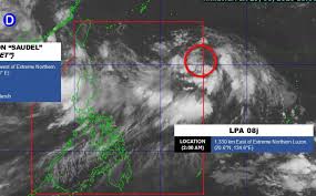
As of 10 PM local time on August 29, the center of Saudel was approximately 1,055 kilometers northwest of the northern tip of Luzon. The system is currently exhibiting maximum sustained winds of around 45 km/h near its center, with gusts reaching up to 75 km/h. Saudel is moving west-southwest at a speed of about 30 km/h.
Forecast models indicate that Saudel may move across mainland China in the coming days, potentially weakening into a low-pressure area. However, there is a possibility that it could regain strength after moving into the southern waters of the South China Sea. Subsequently, it is expected to shift northeast towards Taiwan.
PAGASA has stated that while the likelihood of Saudel making direct landfall in the Philippines is low, the storm could still influence local weather by enhancing the southwest monsoon (Habagat) in the upcoming week. Residents are advised to stay updated on weather reports, as the storm's trajectory and intensity may change.
In addition to Saudel, PAGASA is also closely monitoring another weather system, designated as low-pressure area 08j, which is currently within the Philippine Area of Responsibility (PAR) and has a high likelihood of developing into a tropical depression within the next 24 hours.
Given the potential for both systems to impact weather conditions, PAGASA urges the public to remain vigilant and informed about the latest updates.