Tropical Depression Off Philippines May Strengthen into Typhoon
A tropical depression located offshore from the Philippines has the potential to intensify into a typhoon.
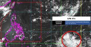
A tropical depression, designated as 07c, is situated near the Philippines and is expected to intensify into a tropical storm by tomorrow, July 17. According to the latest update from the Philippine Atmospheric, Geophysical and Astronomical Services Administration (PAGASA), this depression is currently located approximately 2,915 kilometers east of Mindanao, outside the Philippine Area of Responsibility (PAR).
In a forecast issued earlier today, PAGASA noted that there were no other low-pressure areas being monitored. The emergence of this depression aligns with PAGASA's long-term forecast released on June 16, which predicted two consecutive low-pressure systems to develop near the Philippines in the latter half of July.
The latest storm forecast indicates that one of these low-pressure areas will form along the eastern boundary of PAGASA's Tropical Cyclone Information Dissemination (TCID) area between July 16 and July 22. This system is likely to strengthen into either a tropical storm or a tropical depression, with low to moderate intensity.
Furthermore, the depression is expected to persist and move westward during the week of July 23 to July 29, potentially intensifying to low to moderate levels as it approaches the northeastern region of the TCID and PAR.
Another low-pressure system may also develop in the eastern part of the TCID during the same period, but it is less likely to strengthen into a storm as it continues moving northwest toward the Philippines.
The 07c depression is also being monitored by the Joint Typhoon Warning Center (JTWC) of the U.S. Navy, which has designated it as 90W. JTWC's weather forecasters indicate that 90W is located in the western Pacific and is unlikely to develop into a tropical storm within the next 24 hours. However, it is currently maintaining maximum sustained winds of approximately 35-45 km/h.
Analysis shows that 90W is in a favorable environment for development, characterized by low wind shear, good divergence at upper levels, and warm sea surface temperatures ranging from 29 to 30 degrees Celsius. All forecast models from JTWC agree that 90W will continue moving in a north-northwest direction.