UK and Europe daily weather forecast latest January 23 Heavy snow to blanket across the UK with wintry conditions
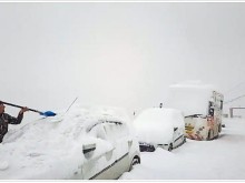
The UK is forecasted to cope with heavy snow up to 20 inches with wintry conditions across the country.
Britain is bracing for a "big snow event" with up to 32 inches of snow as temperatures plunge as low as -15C, forecasters have claimed.
Low pressure from the Atlantic is predicted to bring extreme wintry conditions to much of the UK this month. Heavy snow is forecast from Wednesday, January 20, with Inverness and Fort William in Scotland likely to see 12 inches (32cm) settling. Central Scotland is then expected to see a staggering 32 inches (81cm) of snow on Wednesday, January 27, the latest snow depth maps from WXCHARTS show.
Northern parts of England may also be hit with seven inches (18cm) on the same day, including Newcastle and Northumberland.
South-eastern areas could also see at least two inches (7cm) fall at the end of the month. Temperatures are forecast to plunge to subzero levels, with lows of -11C in Newcastle on Sunday, January 24, and Scotland seeing a bitterly cold -15C in central parts on January 27.
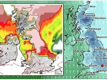
| UK long-range forecast: Britain is bracing for bitterly cold air in January (Image: WXCHARTS) |
Gavin Partridge, the owner of GavsWeatherVids, warned of a sustained northerly blast blitzing the UK with bitter wintry conditions on Wednesday, January 20. He added rare snow events like this do not happen "all that often".
Mr Partridge said: "We have cold air established not just over the UK but much of Northern Europe and low pressure coming off the Atlantic, with -10C in Scotland."
"It sets up a very, very cold and snowy path that will bring heavy snow and blizzards to many parts as we go into Thursday, January 21."
"Another low pushes up the south, bringing more heavy snow there on the 22nd and a very cold north-easterly wind setting up there as well."
| UK long-range forecast: Temperatures could plunge to -15C (Image: WXCHARTS) |
According to Weather Online, fronts passing eastwards through Wednesday. These will be bringing cloud and rain, some of it heavy in the north and west, the heaviest in western Scotland, Wales and northwest England. The risk of some sleet on hills in the north. Drier in the east at first, although rain will be reaching here through the afternoon. Conditions turning more drizzly in the west with low cloud and fog affecting these areas. Highs at 11C in Ireland and much of Wales, central and southern England. Colder north and east with tops near 2 to 4C here.
Cold with rain, sleet and snow across northern UK, lasting most of the day in western areas. Further south, rain band moving east followed by milder but rather cloudy weather, Met Office reported.
Remaining unsettled with areas of rain and snow pushing east, snow will mostly be confined to the hills. Rather cold in east areas, but generally milder in the west.
"The heavy snow on January 20 is over Scotland, but then the south will start getting it - so very heavy snow coming into the south, with another big snow event on January 21. It just keeps on coming. We don't see snowy runs like this all that often."
| Photo: Weather Online |
The BBC's long range forecast added a cold snap could spark "volatile" low temperatures across the UK later this month and even snow on lower ground.
The forecast between Monday, January 18 and Sunday, January 24 said: "There is still a lot of uncertainty on the westward extent of the cold air, and we could see a few cold blasts mixed in with our overall milder, wetter weather.
A dry and fine day across Spain and Portugal as well as the Balearics. Rain should largely clear Corsica and Sardinia but it will be breezy along the coasts here. Patchy rain across Italy will become confined to the south leaving northern areas dry. Heavy rain in Greece being confined to the south and clearing to the north. Turkey will remain mostly dry but northern areas seeing heavy spells of rain and thunderstorms.
A band of rain, sleet and snow will push from north to south down France, the Low Countries, Germany and into Switzerland, Austria and the Czech Republic. Poland, too, will see rain turn to sleet and snow as the front passes from west to east here. Dry down the Balkan States.
| Photo: Stirimeteo |
| Photo: Stirimeteo |
A colder day across Scandinavia with snow affecting central and coastal areas of Norway as well as northern Sweden with some rain, sleet and snow moving into the far south here. Rain intially across the Baltic States before turning to sleet and snow. Southern parts of Finland will see snow falling too but the north should remain dry. Denmark will see rain in the south turn to snow on the back edge of the front as it clears then it will be brigther but cold with wintry showers pushing in from the northwest.
A fair day in Spain and Portugal. Corsica and Sardinia may have some showers. These showers also affecting southern Italy. The rest of Italy should be dry and bright with more sunny spells. Cloud and rain in southern Greece. More persistent rain in Turkey, snow in central and northern areas.
| Photo: Weather Online |
Cloud and drizzle in much of France, moe persistent rain north and east. Cloud increases in the Low Countries. Breezy in Germany with some rain in the north. Further periods of rain and showers in Poland. Austria, Hungary and Switzerland will be cloudy with periods of rain, snow in Switzerland.
Windy and cold with sleet and snow in Denmark. Further snow in the Baltic States and the south of Finland where gales will lead to blizzards in places. Windy over much of Sweden with periods of snow in central and southern areas. Cold and fair in Norway.