UK and Europe daily weather forecast latest January 23 Heavy snow to blanket across the UK with wintry conditions
The UK is forecasted to cope with heavy snow up to 20 inches with wintry conditions across the country.
According to Express, wintry conditions are expected to move across the UK tonight, with forecasters predicting large parts of the country will experience snowfall on Saturday. For the majority of Scotland, parts of the North of England and Wales, a blast of Polar air is expected to strike bringing the worst of the conditions. The band of cold air is expected to hit the UK within hours as large swathes of the country wake up to wintry conditions on Saturday morning.
While Scotland is expected to have up to 13 inches of snow, northern parts of England could see snowfall reaching 7.8 inches (19.8cm).
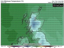
Not only are forecasters predicting snowfall overnight but WX Charts predicting temperatures could fall to -10C (14F) in some areas of the UK.
While the snow is isolated to the North and Scotland, the sub-zero temperatures are widespread across the country and will struggle to hover above 2C (35.6F) throughout Saturday.
The snowfall will persist for most of Saturday according to the forecaster with levels remaining close to 11 inches (27.94cm) throughout the afternoon.
| The polar vortex will send cold air toward the UK triggering snow (Image: Severe Weather Europe) |
In separate graphs indicating the temperature throughout the day, it is not expected to rise much above 3C (37.4F) for much of the day.
In the evening, however, the mercury is expected to fall below freezing from 6pm on Saturday.
These temperatures are primarily focused in the South of England and Wales, although the rest of the UK will see figures remaining in the low single digits.
Although the temperatures will remain low, snow depth charts have stated the levels will gradually improve throughout the day on Saturday in Scotland and the North of England.
Due to the poor conditions expected over the next few days, the Met Office has issued yellow weather warnings for snow and ice until Sunday Morning.
The Met Office predicted from this evening onwards: “Outbreaks of rain, sleet and snow across central and some southern areas will clear overnight, with clearing skies allowing a widespread frost, ice and patchy freezing fog."
“Further cloud and some sleet and snow into north-west Scotland later. Icy start, then some sunshine, but also areas of low cloud and fog slow to clear in the south. Cloudier in north with occasional rain, and sleet in places at first.”
| Freezing fog: The UK has awoken to freezing temperatures following the coldest night of winter so far (Image: GETTY) |
Further yellow weather warnings have also been issued for Scotland for Sunday and Monday due to heavy rain expected.
Looking ahead to the end of the month, the BBC did warn of more cold spells as we head into February.
They said: “For the end of January, the more progressive pattern with frequent Atlantic weather fronts is expected to continue."
“The jet stream will often be overhead, leading to temperatures being near or a bit above average, especially in the south."
“The fronts and nearby jet stream will make for a rather changeable weather pattern as lows move through quickly and brief ridges of high pressure drift in between them."
“These highs will bring some colder air and make for frosty nights at times. Heading later into January there is a growing risk of some of these cold snaps become more widespread and longed-lived.”
| Photo: Weather Online |
According to Weather Online, the ridge of high pressure persists for many on Sunday, bringing dry and bright weather to much of England, Wales and Ireland. A front drifts over Scotland bringing outbreaks of rain at times over northern parts of the country and to the Northern Isles. This locally heavy to the northwest and for Orkney while it may turn to sleet and snow for Shetland. Staying cold with high temperatures ranging from 3 to 7C.
Heavy outbreaks of rain and snow continue for Spain, these becoming concentrated to the northeast. Patchy rain elsewhere but with the driest of conditions towards the west and over Portugal. Cloudy and wet across the Balearics with the rain band shifting north over Italy and Corsica. Rain clearing across Sardinia. Rain also pushing in to Greece and then Turkey. Dry and fine for eastern Turkey.
Largely dry and fine across France and the Low Countries although there is the risk of one of two showers about to the northwest. Rain, sleet and snow across east Germany while western and central areas staying largely dry. Dry across the Alpine countries and for the Czech Republic, Slovakia and Hungary. Some scattered wintry showers across Poland but plenty of dry weather to be had here.
| Photo: Stirimeteo |
| Photo: Stirimeteo |
A largely dry day across Scandinavia, including Denmark, however, a low pressure system will push into west Norway later on increasing coastal winds and pushing snow into westernmost areas. A few scattered wintry showers through the Baltic States early on but largely dry and fine here and for Finland.
According to Weather Online, patchy outbreaks of rain, sleet and snow persist across northern and eastern Spain while a few showers develop along the southern coast. Largely dry and fine elsewhere and for Portugal. Outbreaks of rain for the Balearic Islands, Corsica, Sardinia and much of Italy. Tending drier to the far north of Italy (where it will also be bright) and to the far south and over Sicily where it will be cloudier. Rain, which may be locally heavy, clears north from Greece and Turkey to leave a dry day here. A few showers may linger along northern coasts.
| Photo: Weather Online |
A largely dry and fine day for much of mainland Europe. High pressure leads to the risk of some early mist and fog patches while there will be variable amounts of cloud around. This applies to France, the Low Countries, Switzerland, Austria, Hungary, the Czech Republic, Poland and Slovakia. Some patchy snow may creep into far southern parts of Austria and Hungary later.
Winds pick up over Scandinavia and bands of rain, sleet and snow edge from west to east over Norway, Denmark, Sweden, Finland and, later, into the Baltic States.


