Tropical Depression Near the East Sea Strengthening Rapidly
A tropical depression near the East Sea is expected to strengthen into a storm within the next 24 hours.
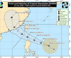
Tropical Depression Noul, which is currently located near the South China Sea, is expected to intensify into a tropical storm as it moves through the region. According to the latest updates from the Philippine Atmospheric, Geophysical and Astronomical Services Administration (PAGASA), the depression is currently about 830 kilometers east of Northern Luzon, with maximum sustained winds of 45 km/h and gusts reaching up to 55 km/h.
On July 23, the Japan Meteorological Agency (JMA) issued its first tropical storm warning for Noul, named after the Korean word meaning "red sky." The JMA anticipates that the system will reach tropical storm strength by July 24. However, unlike other forecasting agencies, JMA does not expect Noul to become a strong tropical storm.
According to the Hong Kong Observatory, the tropical depression near the Philippines could strengthen and move closer to Hong Kong by the weekend. The forecast indicates that Noul will enter the northeastern part of the South China Sea and likely head towards the eastern waters of Guangdong province, China, by the end of the week.
The latest trajectory predictions suggest that Noul will make landfall on July 26 in the Huệ Lai district of Yết Dương city, Guangdong province, at a strong storm intensity, with maximum winds near the center reaching approximately 120 km/h. The predicted landfall location is less than 400 kilometers east of Hong Kong. As a result of Noul, strong winds, heavy rainfall, and thunderstorms are expected along the Guangdong coastline from the night of July 25 to July 26.
Furthermore, the Central Weather Administration of Taiwan has noted that the tropical depression could develop into Noul between July 23 and July 24. The storm is expected to be closest to Taiwan on July 24 and 25, causing significant rainfall in various areas.
Initially, forecasts indicated that the storm would pass through the Philippines before entering the South China Sea. However, recent updates from several countries suggest a more northern trajectory, which may increase its impact on Taiwan. This shift northward means the storm is less likely to be affected by land and will move over warmer waters, potentially allowing it to strengthen further.