Tropical Depression May Form in Gulf of Tonkin, Heavy Rains Expected
A tropical depression is expected to form in the Gulf of Tonkin, with northern provinces bracing for heavy
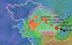
As of early morning on August 21, a tropical depression has moved past Hainan Island in China and into the Gulf of Tonkin. The latest assessments indicate that this weather system could strengthen into a storm, making landfall in the Hai Phong - Quang Ninh region around the night of August 23. Heavy rain is expected to return to Northern Vietnam starting today, with forecasts suggesting it may persist for several days.
At 1 AM today, the center of the tropical depression was located over the eastern waters of the North Gulf of Tonkin, with maximum winds near the center reaching level 6 (39-49 km/h) and gusts up to level 8. According to the National Center for Hydro-Meteorological Forecasting, the tropical depression is situated on a convergence line, interacting with various surrounding weather systems, making its development difficult to predict.
The most likely scenario currently indicates that after entering the Gulf of Tonkin, the tropical depression will move very slowly in a west-northwest direction at a speed of only 3-5 km/h, potentially strengthening into a storm due to warm sea surface conditions. By 1 AM on August 22, the storm center is expected to be located about 180 km southeast of Hai Phong.
The storm is projected to continue moving slowly in a west-northwest direction at a speed of 3-5 km/h, remaining over the Gulf of Tonkin for an extended period. By 1 AM on August 23, the storm center is predicted to be approximately 100 km southeast of Hai Phong. It is expected to approach the mainland of Hai Phong - Quang Ninh provinces by the evening of August 23, before making landfall and gradually weakening.
However, an alternative scenario suggests that the storm's landfall area could shift southward towards the northern delta, targeting Hung Yen - Ninh Binh. Due to the influence of the convergence line associated with the tropical depression, heavy rain has already returned to the Northeast region since early this morning.
Forecasts indicate that from today until tomorrow evening (August 22), the Northeast region and Thanh Hoa will experience moderate to heavy rain, with total rainfall ranging from 70-150 mm, and some areas may see over 300 mm. From August 23, moderate to heavy rain and thunderstorms are expected to continue in the Northeast region and Thanh Hoa, with some areas likely experiencing very heavy rainfall.
Additionally, on August 21, the regions of Nghe An and Ha Tinh will also face moderate to heavy rain and thunderstorms, with rainfall amounts generally between 20-40 mm, and some areas exceeding 80 mm. On the sea, the Gulf of Tonkin (including the special area of Bach Long Vi) will see increasing winds reaching levels 6-7, with gusts near the storm center reaching level 8 and gusts up to level 10, along with waves rising to 2.5-3.5 meters, resulting in rough seas. Vessels operating in these dangerous areas are at risk of being affected by thunderstorms, strong winds, and large waves.
Both scenarios for the tropical depression indicate significant rainfall in Northern Vietnam, as assessed by the National Center for Hydro-Meteorological Forecasting.