Tropical Depression Luis to Hit Land with Heavy Rainfall
Tropical Depression Luis is expected to make landfall in the northern region of Luzon, Philippines, bringing
Tropical Depression Neneng Approaches Land, Expected to Make Landfall Soon
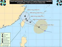
On August 19, the Philippine Atmospheric, Geophysical and Astronomical Services Administration (PAGASA) reported that Tropical Depression Neneng continues to maintain its strength while moving northwest over the waters east of Taiwan. At 10 AM on August 19, the center of Neneng was located approximately 530 km east-northeast of Itbayat, Batanes, with coordinates of 22.6 degrees North and 126.6 degrees East.
Neneng has maximum sustained winds of 55 km/h near its center, with gusts reaching up to 70 km/h and a central pressure of 1,002 hPa. The system is moving northwest at a speed of 30 km/h, with strong winds extending up to 380 km from the center of the depression.
PAGASA has advised the public to monitor heavy rain warnings due to the southwest monsoon (Habagat) affecting the region. Strong winds and gusts are expected in most parts of Luzon and Visayas, including the Zamboanga Peninsula, Northern Mindanao, and Davao regions on August 19 and 20.
By August 21, areas affected will include most of Luzon, Panay Island, Negros Occidental, Northern Samar, and Davao Oriental. Coastal waters are predicted to become rough, with waves potentially reaching heights of 3.5 meters in certain areas like Ilocos Norte, Zambales, and the Lubang Islands. Waves up to 3 meters are expected in Ilocos Sur, La Union, and parts of Batanes, Pangasinan, Batangas, Occidental Mindoro, and the Calamian and Kalayaan Islands.
PAGASA has cautioned small boat operators, especially motorized ones, to exercise caution when venturing out to sea and to avoid operations in rough sea conditions if possible. The forecast indicates that Neneng will continue moving primarily northwest and may approach or make landfall on the northern coast of Taiwan by the afternoon or evening of August 20.
While the center of the depression is expected to remain over the waters of the Philippines throughout the forecast period, it is projected to maintain its tropical depression status for the next 36 hours before weakening into a remnant low near Taiwan by the morning of August 21. However, PAGASA has not ruled out the possibility of an earlier weakening.
The agency urges residents and disaster risk management authorities to take necessary precautions to protect lives and property and to adhere to local government advisories in high-risk areas that may be affected by heavy rain, strong winds, and rough seas.