Tropical Depression Near the East Sea Strengthening Rapidly
A tropical depression near the East Sea is expected to strengthen into a storm within the next 24 hours.
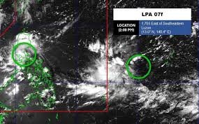
A low pressure system has officially made landfall in the Philippines, causing heavy rain and thunderstorms across many regions. As of 2 PM local time on July 29, the low pressure area, designated LPA 07e, was located near Macalelon in Quezon province, with coordinates approximately 13.8°N and 122.2°E. The Philippine Atmospheric, Geophysical and Astronomical Services Administration (PAGASA) has indicated that this system is unlikely to develop into a tropical depression or storm within the next 24 hours.
In addition, another low pressure system, LPA 07f, is situated about 1,755 km east of Southeast Luzon, at coordinates 13.0°N and 140.4°E, and is also expected to remain stable without intensifying into a tropical depression or storm in the near future.
The impact of the low pressure system is being felt in the capital city of Manila, as well as in Central Luzon, Calabarzon, Mimaropa, Bicol region, Western Visayas, and several provinces including Quirino, Nueva Vizcaya, Benguet, La Union, and Pangasinan. These areas are forecasted to experience overcast skies with scattered rain showers and thunderstorms. Some regions may see heavy rainfall, increasing the risk of flash floods and landslides.
Elsewhere in Luzon, the eastern winds are maintaining a cloudy atmosphere with intermittent rain showers and thunderstorms. On the East Sea, the National Center for Hydro-Meteorological Forecasting reported that as of July 29, strong winds of level 5, with gusts reaching level 6, were recorded at Phu Quy station. The waters from Ho Chi Minh City to Ca Mau, as well as the Gulf of Thailand and northern East Sea (including the Paracel Islands), are also experiencing scattered rain and thunderstorms.
Forecasts for the next 24 hours indicate that the waters from Khanh Hoa to Ho Chi Minh City and the western part of the central East Sea will see southwest winds of level 5, occasionally reaching level 6, with gusts of level 7-8. The sea conditions are expected to be rough, with wave heights between 2.0 to 3.0 meters.
Additionally, on the night of July 29 and throughout July 30, areas including the Gulf of Tonkin, from Khanh Hoa to Ca Mau, and the northern and southern East Sea (including the Spratly Islands) are predicted to experience rain and thunderstorms. There is a high likelihood of tornadoes and strong gusts of wind reaching levels 7-8, with waves exceeding 2.0 meters.
From July 30 to 31, the waters from Khanh Hoa to Ho Chi Minh City and the western part of the central East Sea will continue to experience southwest winds of level 5, with occasional level 6 gusts, and wave heights of 2.0 to 3.0 meters, indicating rough sea conditions. The disaster risk level at sea is assessed at level 2.
All vessels operating in these areas are at high risk of being affected by strong winds and large waves. Residents and tourists planning to visit these coastal regions are advised to closely monitor weather forecasts, follow local guidelines, and avoid venturing out to sea during rough conditions to ensure safety.