Tropical Depression Near Philippines Expected to Intensify
A tropical depression near the Philippines is anticipated to strengthen into a tropical storm within the
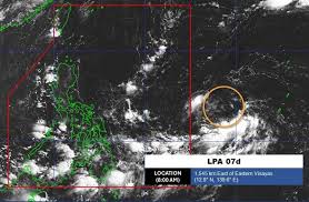
A new low pressure system has emerged near the East Sea, outside the responsibility area of the Philippines. According to the latest update from the Philippine Atmospheric, Geophysical and Astronomical Services Administration (PAGASA), the system was located at approximately 12.8 degrees North latitude and 139.6 degrees East longitude as of 8 a.m. local time today.
The maximum wind speed near the center of the low pressure area is recorded at 35 km/h. PAGASA forecasts a moderate chance of this system developing into a tropical depression or storm within the next 24 hours.
As it is still far from the mainland, the low pressure system has not yet caused significant impacts on nearby land areas. However, the National Center for Hydro-Meteorological Forecasting has reported that the northern Gulf of Tonkin and the eastern waters of the central East Sea, as well as the southern part of the South China Sea, are experiencing scattered rain and thunderstorms.
For today and tonight, the northern Gulf of Tonkin, the eastern waters of the central East Sea, and the southern part of the South China Sea (including the Spratly Islands) are expected to see scattered rain and thunderstorms. There is a possibility of tornadoes, strong winds reaching levels 6-7, and waves exceeding 2.0 meters.
All vessels operating in these areas are at risk of being affected by tornadoes, strong winds, and high waves. Residents and tourists planning to visit these coastal regions should closely monitor weather forecasts, follow local guidance, and avoid going out to sea during rough conditions to ensure safety during their travels.