Tropical Depression Noul Expected to Impact the South China Sea
Tropical Depression Noul, also known as Kiyapo in the Philippines, is forecasted to strengthen and affect
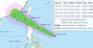
The national weather forecasting center has announced that a tropical depression currently located approximately 600 km east of Luzon, Philippines, is expected to strengthen into Storm No. 2 in the East Sea. By the evening of July 24 to the early morning of July 25, the storm will move towards the northeastern region of the northern East Sea.
With an 80% probability, Storm No. 2 is predicted to make landfall in Quang Dong province, China, on July 26, with minimal direct impact on Vietnam's mainland. However, the storm will cause significant wave heights of 5 meters in the East Sea.
From the evening of July 24, the northeastern area of the northern East Sea will experience increasing winds, reaching levels of 6 to 7, and potentially escalating to 8 to 9. Near the storm's center, winds could reach levels 10 to 11, with gusts up to level 13 and waves between 3 to 5 meters, leading to rough seas.
Due to the storm's influence, from July 23 to 25, widespread heavy rainfall is expected in northern provinces, with total rainfall ranging from 70 to 150 mm, and some areas may exceed 300 mm. The provinces of Cao Bang, Thai Nguyen, Tuyen Quang, Lao Cai, Lai Chau, Dien Bien, and Son La are particularly at risk for flash floods and landslides.
During this flooding event, rivers in the northern region are anticipated to see water levels rise by 2 to 5 meters, with some rivers reaching alert levels 1 and 2. The situation poses a significant risk for communities living near these waterways.