Heavy Rain in Northern Vietnam Due to Maysak Storm
Northern Vietnam is experiencing heavy rainfall due to the influence of Storm Maysak. Areas including Quang
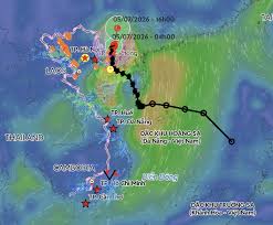
The remnants of Tropical Storm Maysak, known as Storm No. 1, are causing significant rainfall in Northeast Vietnam, despite the storm having moved into southern Guangxi, China, where it is weakening. As of July 5, meteorologists reported that the storm's center had reached an intensity of level 8, with gusts up to level 10, moving northeast at a speed of 5-10 km/h.
Over the next 6-12 hours, the storm is expected to continue on its northeast path at a speed of 10-15 km/h, gradually weakening into a tropical depression and eventually dissipating. Although the storm has exited Vietnam, its remnants are still producing strong winds of levels 6-7 and gusts of level 8 in Quang Ninh province.
Heavy rains are anticipated, which could lead to flooding in urban areas, industrial zones, and low-lying regions, as well as flash floods and landslides in mountainous areas, particularly in Northeast Vietnam. Local authorities and residents are advised to closely monitor weather forecasts and warnings, remaining vigilant until the rain and winds subside.
On the morning and afternoon of July 5, the northern Gulf of Tonkin, including the special economic zones of Bach Long Vi, Van Don, Co To, and Cat Hai, is expected to experience strong winds of levels 6-7 and gusts of levels 9-10. Coastal areas in Quang Ninh will also see similar wind conditions, although forecasts suggest that winds on land will gradually decrease after 10 AM.
From early morning until the end of July 5, the southern cloud system associated with the storm's remnants will continue to bring heavy rainfall, with expected precipitation of 40-90 mm across the northern region, and localized areas receiving over 120 mm. Specifically, Northeast Vietnam could see rainfall of 100-200 mm, with some areas exceeding 300 mm.
Tropical Storm Maysak is the first storm to impact the East Sea in 2026. While it did not reach extreme intensity (maximum level 9, gusts level 11), its slow movement resulted in prolonged effects along the coast of Quang Ninh before making landfall, leading to sustained strong winds in areas like Mong Cai and the northeastern coastal region.
Due to the storm's remnants, strong winds have been recorded in various locations, including level 9 winds with gusts up to level 11 at Bach Long Vi, and level 9 winds with gusts reaching level 12 in Mong Cai. Co To recorded level 8 winds with level 10 gusts, with sea waves reaching heights of 2.25 meters. The Quang Ninh area has experienced heavy rainfall, with Mong Cai reporting 247.6 mm of rain from the evening of July 4 to the morning of July 5.
Looking ahead to the current typhoon season, meteorological authorities indicate that due to the El Niño phenomenon, the number of storms in the East Sea is expected to be below the historical average, with around 8-10 storms anticipated, of which 3-5 may impact the mainland. The peak period for storms is expected to be from July to September in the northern region, and from October to November in the central region, with the possibility of affecting the southern region in the later months of the year.