Tropical Depression May Become a Storm Soon
A new tropical depression, designated as TD 19W, is moving northeast and is expected to interact with
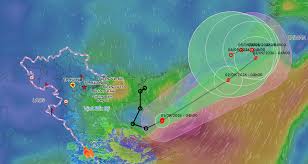
The tropical depression that weakened from Storm Saudel has strengthened again, now classified as Storm Number 5 in the East Sea. According to the National Center for Hydro-Meteorological Forecasting, as of early September 1, the tropical depression in the western waters of the northern East Sea has intensified into a storm.
Storm Number 5, internationally named Saudel, originated in the Northwest Pacific on August 9. After passing through the northern Mariana Islands, it moved over southern Japan before making landfall in Fujian Province, China, on August 28. Following its landfall, the storm shifted southeast towards Guangdong Province, weakening into a tropical depression and then into a low-pressure area.
By the morning of August 31, this low-pressure area moved down to the northern East Sea and regained strength as a tropical depression, eventually becoming a storm early today. As of 4 AM on September 1, Storm Number 5 was located in the western waters of the northern East Sea, approximately 240 km north of the Paracel Islands. The maximum wind speed near the storm's center was recorded at level 8 (62-74 km/h), with gusts reaching level 10.
Forecasts indicate that today and tomorrow, Storm Number 5 will move northeast towards the Taiwan Strait at a speed of 15-25 km/h, with little change in intensity. By 4 AM on September 3, the storm is expected to be located in the northeastern waters of the northern East Sea, maintaining its strength at level 8, with gusts of level 10.
During the day and night of September 3, the storm may change direction and move slowly northwest, potentially weakening into a tropical depression. By 4 AM on September 4, the tropical depression is anticipated to be in the southern waters of Fujian Province, China, with a strength of level 7 (50-61 km/h) and gusts of level 9.
Due to the effects of Storm Number 5, the northern East Sea (including the Paracel Islands) is expected to experience strong winds of levels 6-7, with gusts of levels 8-9, and wave heights of 2-4 meters. Areas near the storm center may see winds of level 8, gusting to level 10, with waves reaching heights of 3-5 meters, leading to rough seas.
In addition, the tropical convergence line associated with Storm Number 5 is expected to bring scattered rain and thunderstorms from Quang Tri to Da Nang today, with rainfall amounts ranging from 10-30 mm, and localized areas possibly exceeding 50 mm. Rainfall in these areas is expected to gradually decrease tonight.
Throughout the Central Highlands and Southeast regions, scattered rain and thunderstorms are also forecasted, with rainfall amounts between 10-30 mm, and some areas may see over 60 mm. Meanwhile, the northern region (excluding Dien Bien, Lai Chau, and Son La) is experiencing hot weather today, with temperatures commonly reaching 35-37 degrees Celsius, and some areas exceeding 37 degrees Celsius. From September 2, the heat in the northern region is expected to ease.