Tropical Depression in the East Sea Likely to Strengthen into a Storm
A tropical depression in the East Sea is moving northwest and is expected to strengthen into a storm within
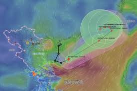
On the morning of September 1, 2026, a tropical depression in the western region of the North East Sea intensified into Tropical Storm Saudel, officially designated as Storm No. 5. At 4 AM, the storm was located approximately 240 km north of the Paracel Islands, with maximum sustained winds near the center reaching 62-74 km/h and gusts up to level 10.
Similar to previous storms, Saudel is forecasted to follow an unusual path. Between September 1 and 2, the storm is expected to move quickly at a speed of 20-25 km/h towards the northeastern part of the North East Sea, maintaining its intensity at level 8 with gusts of level 10. After September 3, the storm will shift direction to the northwest and then to the west, moving very slowly at only 3-5 km/h, approaching the coast of Guangdong, China, where it is predicted to weaken into a tropical depression.
The impact of Storm No. 5 will bring strong winds of levels 6-7 and gusts of levels 8-9 to the North East Sea, including the Paracel Islands, with wave heights reaching 2-4 meters. Near the storm's center, winds will be at level 8, with gusts up to level 10, and waves could reach heights of 3-5 meters, causing rough seas. Vessels operating in these hazardous areas are at risk of severe weather conditions, including thunderstorms, strong winds, and high waves.
As the storm draws in moist cloud formations, northern Vietnam is experiencing a heat wave today, with temperatures soaring to 35-37 degrees Celsius in most areas, and some locations exceeding 37 degrees. This trend is expected to continue until September 2, when temperatures may start to decrease.
In central Vietnam, thunderstorms are still affecting Quang Tri, Hue, and Da Nang, with rainfall amounts between 10-30 mm, and some areas experiencing over 50 mm. The rain is expected to lessen tonight. By September 2, the weather from Thanh Hoa to Da Nang and eastern Quang Ngai will also see a heat wave, with similar temperatures as the north.
The Central Highlands and southern regions will continue to experience scattered thunderstorms this evening, with rainfall amounts of 10-30 mm and isolated areas receiving over 60 mm. Thunderstorms may also bring risks of tornadoes, lightning, hail, and strong winds.
As the tropical depression strengthens into a storm, concerns grow about its potential landfall in Vietnam. The situation remains dynamic, and residents are advised to stay updated on weather forecasts.