Severe Winds Hit Bach Long Vi Island as Storm No. 1 Approaches
Bach Long Vi Island is experiencing severe winds as Storm No. 1 makes landfall. The storm has brought winds
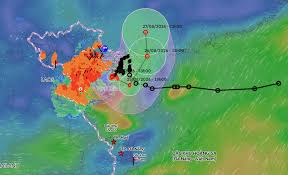
Typhoon No. 4, known internationally as Narra, is currently exhibiting complex movement patterns over the Gulf of Tonkin. As of August 24, the storm has been recorded with winds reaching level 9, with gusts up to level 11, particularly affecting areas such as Bạch Long Vĩ in Hải Phòng and Cô Tô in Quảng Ninh.
At 1 PM on August 24, the center of the typhoon was located approximately 115 km southeast of Quảng Ninh and 105 km southeast of Hải Phòng. The maximum sustained winds near the center of the storm are estimated to be between 75-88 km/h, with gusts reaching 11. The storm is currently moving southwest at a speed of about 5 km/h.
Forecasts indicate that by 1 PM on August 25, the typhoon will change direction to the southeast and continue moving slowly at the same speed over the eastern Gulf of Tonkin. The storm's intensity is expected to remain at level 9 with gusts up to level 11. The areas at risk during this time include Bạch Long Vĩ, Vân Đồn, Cô Tô, Cát Hải, and Hòn Dấu islands.
By 1 PM on August 26, the storm is predicted to shift to a northeast direction, moving at 5-10 km/h towards the coastal waters of Guangxi, China. During this transition, the typhoon is expected to weaken into a tropical depression, with maximum winds decreasing to level 7 and gusts to level 9. A day later, the depression is anticipated to continue northward into Guangxi, further weakening into a low-pressure area.
The impact of Typhoon No. 4 is already being felt along the coastal areas of Quảng Ninh, Hải Phòng, and Hưng Yên, with winds reaching levels 6-7 and waves rising to 2-3 meters. In regions close to the storm's center, wind speeds may reach levels 8-9 with gusts of 10-11, and waves could reach heights of 3-5 meters, creating very rough seas.
Due to the storm's effects, there is a risk of damage to roofs, temporary structures, and downed trees and billboards, which could impact electrical systems and transportation. Notably, from the afternoon of August 24 to the morning of August 25, areas in the northern delta and from Thanh Hóa to Hà Tĩnh are forecasted to experience moderate to heavy rainfall, with totals ranging from 50-100 mm, and localized areas potentially exceeding 180 mm. This heavy rainfall may lead to urban flooding, particularly in industrial zones and low-lying regions, and increase the risk of flash floods and landslides in mountainous areas.
Authorities have also issued warnings about the potential for thunderstorms, whirlwinds, and strong gusts due to the storm's circulation.