Super Typhoon Dolphin Maintains Peak Strength Heading Towards East Asia
Super Typhoon Dolphin continues to maintain its peak strength, with many areas in East Asia advised to
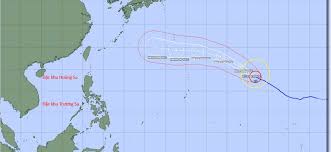
The National Center for Hydro-Meteorological Forecasting has issued a warning for Northern Vietnam, Thanh Hoa, and Nghe An as they prepare for increased thunderstorms and heavy rain from August 1 to 2. The weather is expected to worsen in the evening of August 2, with localized areas experiencing very heavy rainfall.
Typhoon Dolphin, currently located approximately 2,730 kilometers southeast of Tokyo, Japan, continues to maintain its intensity with maximum winds near the center reaching 216 km/h, classified as a level 17 storm. The storm is moving west-northwest at a speed of 20-25 km/h and is expected to maintain its strength in the short term.
The Japan Meteorological Agency has classified Dolphin as a severe typhoon, with wind speeds potentially reaching up to 287 km/h. The storm's strong winds extend over a wide area, with a radius of 200-400 km for winds of level 7, and 120-160 km for level 10 winds.
Weather forecasts for August 1 indicate that various regions across the country will experience cloudy conditions with scattered rain and thunderstorms. In Hanoi, the temperature is expected to range from 25-32 degrees Celsius, while other areas such as the Northwest and Northeast will also see similar weather patterns, with risks of tornadoes, lightning, hail, and strong winds during thunderstorms.
Residents are advised to remain cautious and prepared for severe weather conditions, especially in the affected areas. The forecast suggests that the storm will continue to influence weather patterns across Vietnam, leading to potential disruptions and hazards.