Tropical Depression Strengthens into Typhoon Noul
A tropical depression near the East Sea has intensified into Typhoon Noul. Expected to enter the East Sea
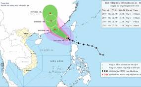
The National Center for Hydro-Meteorological Forecasting has reported that Typhoon Noul is expected to strengthen significantly in the coming hours. As of 7 AM on July 25, the typhoon was located approximately 510 kilometers southeast of Hong Kong, with maximum winds near the center reaching level 11 (103 - 117 km/h) and gusts up to level 13.
Forecasts indicate that within the next 24 hours, Noul will continue to move northwest at a speed of 20-25 km/h, potentially increasing in strength to level 12, with gusts reaching level 14. By 7 AM on July 26, the storm is expected to be located near the southern coast of Guangdong Province, China.
Looking ahead to the next 48 hours, the typhoon is projected to weaken into a tropical depression as it continues its path northwest at 15-20 km/h. By July 27, the center of the depression is anticipated to be over land in Guangdong Province, with wind speeds decreasing to level 6 and gusts up to level 8.
Although Typhoon Noul is primarily heading towards Guangdong, it is expected to have minimal direct impact on Vietnam. However, the northeastern waters of the South China Sea are likely to experience strong winds of levels 6-7 and waves of 3-5 meters. Near the typhoon's center, winds may reach levels 10-11, with waves potentially rising to 5-7 meters, creating hazardous sea conditions.
Maritime activities in the affected areas should be cautious due to the risks posed by thunderstorms, strong winds, and high waves.