Typhoon Noul Expected to Hit the East Sea with Winds Up to Level 13
Typhoon Noul is forecasted to enter the East Sea tonight, becoming Typhoon No. 2, with significant impacts
Typhoon Noul Hits the East Sea, Expected to Intensify
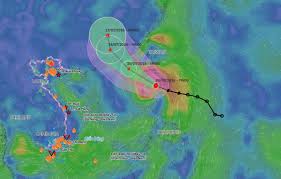
Typhoon Noul officially made landfall in the East Sea on the night of July 24, 2026. According to the National Center for Hydro-Meteorological Forecasting, as of 10 PM on July 24, the storm was located at approximately 19.7 degrees North latitude and 119.8 degrees East longitude, in the northeastern waters of the North East Sea, about 710 km southeast of Hong Kong, China.
The maximum wind speed near the center of the storm reached level 10 (89-102 km/h), with gusts up to level 12. The storm is currently moving in a west-northwest direction at a speed of about 25 km/h.
Forecasts indicate that within the next 24 hours, Typhoon Noul will continue to move primarily in a west-northwest direction at a speed of 20-25 km/h and is expected to strengthen further. By 10 PM on July 25, the storm's center is predicted to be at about 22.1 degrees North latitude and 116.2 degrees East longitude, approximately 230 km southeast of Hong Kong, with intensity reaching levels 11-12, and gusts up to level 14, which is classified as a severe tropical storm.
In the following 24-48 hours, the storm will maintain its west-northwest trajectory at a speed of 15-20 km/h, moving towards the land of Guangdong Province, China, and gradually weakening. By 10 PM on July 26, the storm is expected to weaken to level 8, with gusts up to level 10.
Currently, there is over an 80% probability that Typhoon Noul will make landfall in Guangdong Province, China, with little chance of directly impacting the mainland of Vietnam. However, the northeastern waters of the North East Sea will still experience significant effects from the storm's circulation.
Due to the storm's influence, the northeastern waters of the North East Sea are expected to see strong winds of levels 6-7, increasing to levels 8-10; near the storm's center, winds may reach levels 11-12, with gusts up to level 14. The sea waves are forecasted to be high, ranging from 4-6 meters, and near the storm's center, waves may reach 5-7 meters, leading to very rough seas.
Vessels operating in the danger zone are at high risk of being affected by thunderstorms, strong winds, and large waves. Residents and tourists planning to visit these maritime areas or regions affected by the storm are advised to closely monitor weather forecasts, follow local guidance, and avoid venturing out to sea during turbulent conditions to ensure safety throughout their journey.