Kansas City Weather Update: Rain and Extreme Heat Ahead
Kansas City is bracing for more rain overnight into Friday, with additional showers expected throughout the
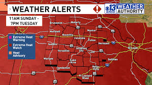
Mid-Missouri is set to experience a significant weather shift as dangerous heat and humidity return after a stretch of cooler and more comfortable conditions. Starting this weekend and continuing into early next week, residents should prepare for rising temperatures and oppressive humidity.
According to the National Weather Service, an Extreme Heat Watch has been issued for the region from Sunday afternoon through Tuesday evening. This watch may be upgraded to an Extreme Heat Warning if conditions worsen. Temperatures are forecasted to reach the upper 80s to lower 90s by Saturday afternoon, with dew points expected to exceed 70 degrees, leading to a heat index that could surpass 100 degrees.
The heat advisory will remain in effect from Saturday afternoon until Monday evening, with daily occurrences of temperatures over 90 degrees anticipated. By Sunday, the heat will intensify, with the heat index potentially reaching as high as 110 degrees.
Residents are advised to limit outdoor activities, especially during peak heat hours. If outdoor exposure is necessary, it is crucial to stay hydrated and take frequent breaks in shaded or air-conditioned areas. The National Weather Service emphasizes the importance of heat safety, urging people to monitor their health and check on neighbors during this extreme weather.
The forecast indicates that this heat trend will persist into early next week, with similar conditions expected on Monday and Tuesday. While there may be a slight improvement in temperatures after Tuesday, above-average conditions are likely to continue throughout the week.
As the region prepares for this weather whiplash, it is essential for individuals to stay informed and take necessary precautions to avoid heat-related illnesses such as heat exhaustion and heat stroke.