Massive Flash Floods Hit Nepal-China Border, Hundreds Missing
A catastrophic flash flood has struck the Nepal-China border, leaving hundreds missing and many feared dead.
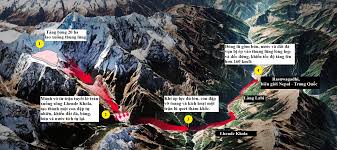
A massive ice block, measuring approximately 20 hectares, equivalent to 28 football fields, fell from the Langtang Lirung mountain in the Himalayas, triggering a devastating flood in Nepal. This incident occurred on August 26, 2023, and was recorded by seismic stations as a 5.2 magnitude event, although it was not an earthquake but rather the result of the ice block's free fall from a height of 1,200 meters.
The ice block, which was about 930 meters long, separated from a glacier on the mountain, which stands at 5,200 meters above sea level. The sudden detachment created a dam across a river, and when this dam broke, it unleashed a torrent of water that rushed down the steep valley at speeds exceeding 160 km/h, carrying with it rocks, debris, and trees, resulting in waves as high as 21 meters.
As a result of this disaster, at least 472 people have been confirmed dead, with around 1,500 individuals reported missing. The rapidity and destructive power of the flood were astonishing; just 13 minutes after the ice block collapsed, a water monitoring station in Syabrubesi was destroyed, halting data transmission. Within 30 minutes, the river's water level rose by 9 meters, sweeping away everything in its path.
Experts attribute the underlying cause of this disaster to climate change, which has led to rising temperatures and the melting of permafrost that once stabilized the glaciers. Over the past three decades, Nepal has lost nearly a third of its glacial ice. Satellite data indicated that a significant amount of snow had melted just 24 hours before the disaster occurred. Although the incident coincided with the peak of the monsoon season, experts believe that heavy rainfall was not the direct cause of the flood.
Moreover, the Himalayas are gradually rising due to tectonic movements, making the glacier terrain increasingly steep and unstable, which increases the likelihood of such catastrophic events. The geographical position of the Himalayas, situated between India and China, traps a significant amount of pollution and particulate matter in the air. Dark soot on the ice absorbs sunlight, accelerating melting, while greenhouse gases trap heat in the atmosphere.
From 2000 to 2023, the region's basins have lost ice at a rate 1.5 times faster than from 1964 to 2000. The steep terrain causes glaciers to rapidly accelerate and compress through narrow river valleys when they collapse from thousands of meters in height. Similar incidents are becoming more frequent in high mountain areas. For instance, in 2016, a glacier in the Aru range of western Tibet broke off, causing a massive ice fall that killed nine herders. In 2021, India reported over 200 fatalities when a glacier collapsed in Uttarakhand.
Traditional flood warning systems are primarily designed to monitor heavy rainfall and are unable to predict glacier collapses. However, satellite technology is emerging as a key solution to this problem. Modern observation satellites like CryoSat-2, Sentinel-1, and TerraSAR-X from the European Space Agency (ESA) can map glacier areas, measure changes in thickness and volume, and detect unusual movements and flow rates. By consistently recording this data, scientists can build a comprehensive picture to start accurately forecasting dangerous glacier collapses, providing a chance for remote communities to survive severe natural disasters.