Local Officials to Survey All Agricultural Land in Hanoi
Local officials in Hanoi are launching a comprehensive campaign to survey and clean up data related to
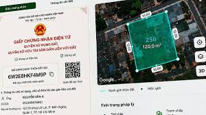
Vietnam is taking significant steps towards modernizing its land management system by introducing electronic land use certificates, commonly referred to as 'red books', associated with unique identification codes. This initiative is part of a broader goal to complete the mapping, documentation, and national database of land by the end of 2027.
According to Dinh Hong Phong, an expert from the Department of Land Management under the Ministry of Agriculture and Rural Development, the shift from traditional administrative methods to a system based on unique identification codes will streamline land identification processes. Previously, identifying a land parcel required various administrative details such as district, province, and map sheet numbers, which could change with administrative adjustments. The new system will assign a unique code to each land parcel, similar to a citizen's identification number, which will be independent of local administrative boundaries and directly derived from the land's geographical coordinates.
By the end of 2025, the government plans to establish a national database for land parcels, requiring that all entries include a unique identification code. Currently, about 69.7 million land parcels have already been integrated into this database and assigned identification codes. Phong shared that the interface for accessing this identification code and the electronic 'red book' is still being refined and is not yet finalized.
This electronic identification system will facilitate the creation of digital land records, allowing citizens to verify ownership and legal status online. It aims to address ongoing issues with counterfeit 'red books' and instances where a single certificate is used multiple times for loans or mortgages. By utilizing this identification code, all changes in land information will be automatically updated in the central database, reducing the risk of document forgery and enabling accurate verification against the national land database.
By 2026, the government aims to complete the data collection for all land parcels, with a full rollout of the mapping and documentation process by the end of 2027. Additionally, efforts are underway to integrate land data with the national citizen identification system, VNeID.
Nguyen Hong Son, Deputy Secretary-General of the National Data Association, emphasized that location data should be viewed as a strategic data infrastructure, similar to citizen and business data. He noted that standardized and connected location data could serve as a nexus for various activities in the digital economy, from logistics to public services.
Major General Nguyen Ngoc Cuong, Director of the National Data Center, echoed this sentiment, stating that location data is foundational for connecting people, organizations, assets, and economic activities. The standardized location system will enhance data sharing among government agencies, boost e-commerce, urban planning, land management, and public service delivery, and support the development of AI applications based on this data.