Typhoon Maysak Approaches Northern Vietnam: Heavy Rain Forecast
Typhoon Maysak is expected to make landfall in the Quang Ninh and Hai Phong regions of northern Vietnam this
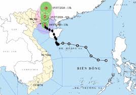
Typhoon Number 1, also known as Typhoon Maysak, is currently located approximately 90 kilometers southeast of Mong Cai in Quang Ninh province. As of 14:00 on July 4, the storm's circulation has been causing strong winds in several islands and coastal areas, including Quang Ninh, Hai Phong, and Hung Yen.
The national meteorological center reported that the storm is expected to have significant impacts on the coastal regions of Quang Ninh, Hai Phong, and Hung Yen, with the strongest winds anticipated between 14:30 and 21:00 as the storm moves inland. Wind speeds have already reached levels of 9 with gusts up to 10 in areas like Bach Long Vi, while Co To recorded winds at level 8 with gusts of level 9.
Forecasts indicate that from the evening of July 4 until the end of July 5, the northeastern region will experience heavy to very heavy rainfall, with total precipitation expected to range from 150 to 250 millimeters, and localized areas possibly exceeding 450 millimeters. Authorities are particularly concerned about the risk of flash floods, landslides, and inundation in mountainous and midland areas.
The meteorological agency urges residents in affected areas to closely monitor the storm's developments and adhere to evacuation and safety guidelines issued by local authorities. The National Civil Defense Steering Committee has issued directives for coastal provinces from Quang Ninh to Khanh Hoa to manage and monitor maritime activities, ensuring the safety of both residents and tourists.
In preparation for the storm, rescue and emergency response forces are on standby, with increased vigilance to address any arising situations. The name Maysak, proposed by Cambodia, translates to 'teak tree' in Khmer, a valuable wood often used in construction and boat building.