Tropical Depression Near the East Sea May Intensify into a Typhoon
A tropical depression, identified as LPA 09g, is moving towards the Philippines and is expected to
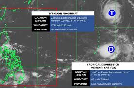
A tropical depression has formed in the Pacific Ocean following the intensification of Typhoon Koguma. According to the latest storm report from the Philippine Atmospheric, Geophysical and Astronomical Services Administration (PAGASA), the depression is situated approximately 2,940 kilometers east of Luzon Island, at coordinates 14.5° N latitude and 149° E longitude.
The maximum sustained winds near the center of the tropical depression are recorded at 45 km/h, with gusts reaching up to 55 km/h. The system is moving in a northeast direction at around 20 km/h and is unlikely to shift back toward the East Sea.
Meanwhile, Typhoon Koguma is positioned about 2,805 kilometers northeast of Luzon, with maximum winds of 175 km/h and gusts up to 215 km/h. The typhoon is moving northwest at a speed of 20 km/h and is currently at its peak intensity, although it is expected to gradually weaken over the coming days. However, it will still maintain strong winds for at least the next two days.
In addition, a previous low-pressure area near the East Sea has dissipated after making landfall in the Philippines. As of early October 11, the waters from Quang Ngai to Ca Mau and the Gulf of Thailand are experiencing rain showers and thunderstorms.
On the same day, the northern waters of the East Sea, including the Paracel Islands, are forecasted to have northeast winds of level 6, with gusts reaching levels 7-8, leading to rough seas. Wave heights are expected to be between 2.0 to 3.0 meters, coming from the northeast.
As night falls on October 11, the northern waters of the East Sea will continue to experience northeast winds of level 5, occasionally reaching level 6, with gusts of level 7, resulting in rough seas. Wave heights will remain between 2.0 to 3.0 meters, also from the northeast.
Furthermore, during the day and night of October 11, the waters from South Quang Tri to Ca Mau, from Ca Mau to An Giang, the Gulf of Thailand, and the western waters of the northern East Sea (including the Paracel Islands) will see rain showers and thunderstorms. There is a high likelihood of tornadoes and strong gusts of level 7-8, with wave heights exceeding 2.0 meters.
Starting October 12, winds in these areas are expected to weaken. The level of disaster risk at sea is classified as level 2.
All vessels operating in the aforementioned waters are at high risk of being affected by strong winds, large waves, and tornadoes during thunderstorms. Therefore, residents and tourists planning to visit these coastal areas should closely monitor weather developments and avoid going out to sea during rough conditions to ensure safety.