Tropical Depression Strengthens into Typhoon Maysak, Heavy Rain Expected
The tropical depression in the Northwest area of the Paracel Islands has intensified into Typhoon Maysak,
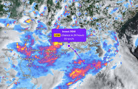
A tropical depression over the East Sea has officially made landfall on July 14, 2026. According to the latest report from the Joint Typhoon Warning Center (JTWC), the depression is currently located inland in Guangdong province, China, and is moving northwest at a speed of 35 km/h.
The JTWC forecasts that this depression is unlikely to strengthen into a tropical storm or typhoon in the next 24 hours. As a result of the depression, widespread heavy rainfall is expected along the coastal areas of Guangdong.
On the morning of July 14, the Phu Quy special economic zone experienced southwest winds at level 5, with gusts reaching level 6, and level 7 gusts reported in Phu Quoc. The northern and central parts of the East Sea, including the Paracel Islands, as well as the waters from Lam Dong to Ca Mau, and from Ca Mau to An Giang, are currently experiencing rain and thunderstorms.
For the day and night of July 14, winds in the waters from Dak Lak to Ho Chi Minh City, the central East Sea, and the eastern part of the northern East Sea are expected to be strong, reaching level 6 with gusts of level 7-8. The sea will be rough, with waves rising to 2-3 meters, and in the central East Sea, waves could reach heights of 2-4 meters.
The western part of the southern East Sea, including the waters west of the Spratly Islands, will see southwest winds at level 5, with occasional level 6 gusts, and waves between 1.5 to 3.5 meters high.
Additionally, the northern Gulf of Tonkin, the waters from Lam Dong to Ca Mau, from Ca Mau to An Giang, the Gulf of Thailand, the northern and central parts of the East Sea (including the Paracel Islands), and the western part of the southern East Sea (including the waters west of the Spratly Islands) are all under the influence of rain and thunderstorms. There is a risk of tornadoes, strong gusts of wind at levels 7-8, and waves exceeding 2 meters during thunderstorms.
On July 15, the waters from Gia Lai to Lam Dong, the central East Sea, and the eastern part of the northern East Sea will continue to experience southwest winds at level 5, with gusts of level 7-8. The sea will remain rough, with waves between 1.5 to 3.5 meters high. The risk level for natural disasters due to strong winds at sea is rated at level 2.
The meteorological agency warns that all vessels operating in these areas are at high risk of being affected by strong winds, large waves, and tornadoes during thunderstorms.
Residents and tourists planning to visit Guangdong during this time should monitor weather developments, check flight schedules, and follow local guidance to avoid disruptions from rain and storms.