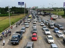
Severe Flooding in Hanoi Due to Heavy Rainfall
Hanoi is experiencing widespread flooding after heavy rains accumulated over 400 mm since September 14. Many
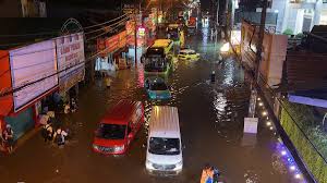
On September 30, Ho Chi Minh City experienced severe flooding on Phan Huy Ich Street, where water levels rose over one meter. This situation was exacerbated by heavy rainfall and the ongoing construction of the Tham Luong canal, which restricted water flow. The rain began around 4:30 PM, with the heaviest downpour occurring between 5:00 PM and 5:45 PM.
The Southern Meteorological Center reported significant rainfall in various areas, including 136 mm in Le Minh Xuan and 108 mm in Thu Duc. The combination of heavy rain and high tides led to the drainage system being overwhelmed, resulting in flooding on at least 12 major roads, with Phan Huy Ich being one of the most severely affected.
Reports indicated that traffic was nearly paralyzed as water flooded into buses and residential areas, disrupting daily life and business operations. By the morning of October 1, some sections of the road remained underwater, causing prolonged traffic congestion. Many vehicles stalled due to the flooding, highlighting the severity of the situation.
Experts noted that the flooding on September 30 was worse than in previous years, primarily due to the construction activities related to the Tham Luong - Ben Cat - Rach Nuoc Len project. The accumulation of dredged materials in the canal has narrowed the waterway, causing water levels to rise and flow back into the drainage system during heavy rains.
Phan Huy Ich Street stretches over 2.5 kilometers through the old Tan Binh district, with some sections located just 200 meters from the Tham Luong canal. The ongoing renovation project is facing challenges in managing approximately 3.3 million cubic meters of dredged materials, as there is no designated disposal area. Consequently, the canal remains partially obstructed, further hindering drainage capabilities.
In addition to Phan Huy Ich, around 11 other roads, particularly in the northwest of the city and near Tan Son Nhat airport, also reported significant flooding. Streets such as Nguyen Van Qua and Phan Van Hon were among those affected. In the former Thu Duc area, roads like To Ngoc Van and Linh Dong were also submerged.
To mitigate flooding, the Traffic Management and Technical Infrastructure Center is operating mobile and fixed pumping stations to assist the drainage system. Major tide control culverts are also being utilized to manage water levels in the canals. Public utility units have increased their presence to address flooding and manage traffic flow during heavy rains or high tides.
In areas impacted by construction, authorities are coordinating with relevant parties to assess the situation and address any factors that reduce drainage capacity. Currently, Ho Chi Minh City has 159 locations that frequently experience flooding, including 76 in the old city, 52 in the old Binh Duong, and 31 in the old Ba Ria - Vung Tau. This year, the city aims to complete nine projects to resolve severe flooding at critical points, including Phan Van Hon and the intersection of National Highway 51 - Huynh Thuc Khang. The Department of Construction has also proposed a drainage and flood control plan for 2026-2030 to address remaining flooding issues.