El Niño Phenomenon Set to Peak in December, Warns UN
The UN's World Meteorological Organization has warned that the El Niño phenomenon will intensify and reach
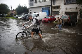
Argentina is currently under the influence of a Super El Niño, leading to a spring season that is both wetter and cooler than usual. This unique weather pattern sets Argentina apart from much of the world, where heat is dominating. According to the national meteorological service (SMN), the country is likely to face significant rainfall, with predictions suggesting that this trend may continue until April of next year.
The latest quarterly forecast indicates that the upcoming months of October, November, and December will see above-normal rainfall, particularly in central and eastern regions of the country. The Litoral area is expected to experience the most pronounced effects, while other regions such as western Santa Fe, Córdoba, central and southern Cuyo, La Pampa, western Buenos Aires, and northeastern Patagonia are also predicted to receive higher than average precipitation.
Conversely, northern and southern extremes of the country may witness different weather patterns. In the eastern Northwest and southern Patagonia, rainfall is expected to remain within normal ranges or even decrease, while the western Northwest is likely to see below-average precipitation. This could lead to a scenario where central and eastern Argentina experiences a wetter climate, while some northern and southern areas remain drier.
Temperature forecasts suggest that much of Cuyo, Córdoba, western Santa Fe, La Pampa, and western Buenos Aires will experience cooler than normal conditions. In contrast, northern regions, particularly the Northwest, are expected to see temperatures rise above normal, with some areas in Chaco, Formosa, Salta, Santiago del Estero, and southwestern Patagonia also trending warmer.
The SMN emphasizes that these forecasts are averages over the three-month period and does not rule out the possibility of extreme weather events, including intense rainfall or temperature fluctuations. As such, short-term forecasts will be crucial for monitoring immediate weather changes.
In the Greater Buenos Aires area, the week ahead is expected to continue with cool temperatures and considerable cloud cover, with isolated rainfall possible. Following recent storms, Thursday will bring mostly cloudy conditions with temperatures ranging from 14°C to 18°C. Friday may see a slight drop in temperatures, with expected highs between 13°C and 17°C.
As instability increases on Saturday, isolated showers are anticipated during the early hours, with temperatures between 12°C and 18°C. Sunday is expected to be more stable, albeit still cloudy, with temperatures ranging from 13°C to nearly 19°C.
Currently, there are no immediate forecasts predicting storms as severe as those experienced earlier in the week, but the situation remains fluid, and short-term predictions will provide more accurate insights into potential rainfall and its intensity.