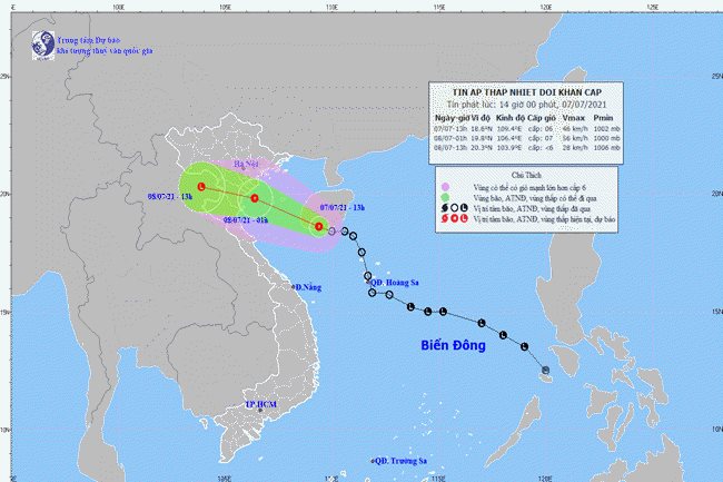
A map detailing the direction of the tropical depression – PHOTO: NATIONAL CENTER FOR HYDRO-METEOROLOGICAL FORECASTING
HCMC – A tropical depression currently active in the East Sea is expected to move toward the Northern Gulf this afternoon, July 7, and pick up strength, bringing strong winds and heavy downpours to the northern and north-central regions in Vietnam, according to the national weather center.
In the next 12 hours, the tropical depression could move west-northwest at around 25 kilometers per hour. By 1 a.m. on July 8, the system may be centered in the waters off Thai Binh and Nghe An provinces, packing strong winds at 39-61 kilometers per hour, gusting at level 9.
For the next 12-24 hours, it could maintain the same direction at some 20 kilometers per hour and leave a direct impact on the Northern Delta and the north-central localities, before weakening into a low-pressure system.
Due to the unfavorable weather conditions, the Northern Gulf including the island district of Bach Long Vi and the waters running from Quang Ninh to Ha Tinh could experience increased strong winds, along with high sea waves and rough seas.
Moreover, the East Sea area, the Northern Gulf and the waters from Quang Tri to Kien Giang could see showers, thunderstorms and probable whirlwinds. Further, northern and north-central provinces are forecast to have heavy rains from now until tomorrow.
At a meeting held this morning to discuss measures to cope with the tropical depression, Tran Quang Hoai, deputy head of the Central Steering Committee for Natural Disaster Prevention and Control, asked localities to closely monitor the developments of the tropical depression and prepare effective response scenarios to ensure the safety of the local people and their properties.
On the same day, the Standing Office of the Central Steering Committee for Natural Disaster Prevention and Control asked provinces from Quang Ninh to Ca Mau to promptly carry out measures against the tropical depression in the East Sea and bad weather in the Southern territorial waters.
The local competent forces also have to regularly monitor weather news and inform boat owners and captains of the location, direction and developments of the tropical depression, so that they can proactively move out of or not enter dangerous areas.
Local competent forces in mountainous regions have to check unsafe houses and residential areas in vulnerable places and prepare plans to relocate affected residents to safer areas.


